WingX Pro7 Version 6.2 Adds Advanced Features | Aero-News Network
Aero-News Network
RSS icon RSS feed
podcast icon MP3 podcast
Subscribe Aero-News e-mail Newsletter Subscribe

Airborne Unlimited -- Most Recent Daily Episodes

Episode Date

Airborne-Monday

Airborne-Tuesday

Airborne-Wednesday Airborne-Thursday

Airborne-Friday

Airborne On YouTube

Airborne-Unlimited-05.05.25

Airborne-NextGen-05.06.25

AirborneUnlimited-05.07.25

Airborne-Unlimited-05.01.25

AirborneUnlimited-05.02.25

Wed, Mar 14, 2012

WingX Pro7 Version 6.2 Adds Advanced Features

Passive RADAR Altimeter, Flight Simulation Mode, and Real-Time Descent Profile Information In Latest Version

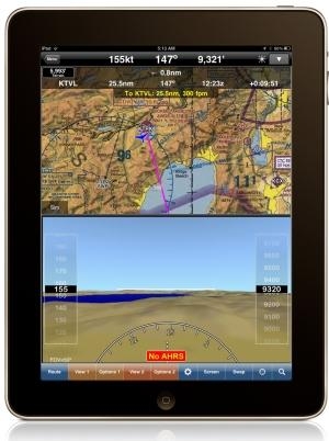
The latest version of WingX Pro7 features new Passive RADAR Altimeter technology for iPad and iPhone. The Passive RADAR Altimeter displays terrain elevation and the aircraft’s approximate AGL; together with Dynamic Terrain Overlays and Synthetic Vision, Hilton Software says WingX Pro7 continues to significantly reduce the risk of Controlled Flight Into Terrain (CFIT). WingX Pro7 Version 6.2 also adds Flight Simulation Mode that enables pilots to pre-fly an entire flight, portion of a flight, or an approach into an airport. Version 6.2’s Moving Map integrates Descent Profile Information that displays descent and landing information to the destination airport or runway touchdown zone.

“We are driven by our desire to increase aviation safety and efficiency," said Hilton Software CEO Dr. Hilton Goldstein. "Our new ‘no hardware, no wires’ Passive RADAR Altimeter solution is revolutionary in mobile aviation computing. WingX Pro7’s new Simulation Mode gives pre-flight a whole new meaning by driving all the pieces of WingX Pro7 including the Moving Map and Synthetic Vision. This enables pilots to simulate an approach into an airport while viewing and interacting with WingX Pro7 as though the approach was actually being flown. Instead of developing a simulator that runs on a desktop, we built flight simulation into the iPad. Another great feature in WingX Pro7 is the addition of Descent Profile Information that not only displays VNAV-like information, but also displays which runway the aircraft is approaching thereby reducing the risk of a runway incursion. We’ve also added tighter integration with Google Earth™ that enables pilots to view their planned route in Google Earth.”

WingX Pro7 Version 6.2 is a free update for registered users and is available now for download from the App Store and iTunes. (Image provided by Hilton Software)

FMI: www.hiltonsoftware.com

Advertisement

More News

ANN's Daily Aero-Term (05.07.25): Terminal Radar Service Area

Terminal Radar Service Area Airspace surrounding designated airports wherein ATC provides radar vectoring, sequencing, and separation on a full-time basis for all IFR and participa>[...]

ANN's Daily Aero-Linx (05.07.25)

Aero Linx: Utah Back Country Pilots Association (UBCP) Through the sharing experiences, the UBCP has built upon a foundation of safe operating practices in some of the most challen>[...]

Classic Aero-TV: Anousheh Ansari -- The Woman Behind The Prize

From 2010 (YouTube Edition): Imagine... Be The Change... Inspire FROM 2010: One of the more unusual phone calls I have ever received occurred a few years ago... from Anousheh Ansar>[...]

NTSB Prelim: Bell 206B

(Pilot) Felt A Shudder And Heard The Engine Sounding Differently, Followed By The Engine Chip Detector Light On April 14, 2025, about 1800 Pacific daylight time, a Bell 206B, N1667>[...]

Airborne-NextGen 05.06.25: AF Uncrewed Fighters, Drones v Planes, Joby Crew Test

Also: AMA Names Tyler Dobbs, More Falcon 9 Ops, Firefly Launch Unsuccessful, Autonomous F-16s The Air Force has begun ground testing a future uncrewed jet design in a milestone tow>[...]

blog comments powered by Disqus


Advertisement

Advertisement

Podcasts

Advertisement

© 2007 - 2025 Web Development & Design by Pauli Systems, LC