WingX Pro7 Version 6.2 Adds Advanced Features | Aero-News Network
Aero-News Network
RSS icon RSS feed
podcast icon MP3 podcast
Subscribe Aero-News e-mail Newsletter Subscribe

Airborne Unlimited -- Most Recent Daily Episodes

Episode Date

Airborne-Monday

Airborne-Tuesday

Airborne-Wednesday Airborne-Thursday

Airborne-Friday

Airborne On YouTube

Airborne-Unlimited-05.19.25

Airborne-NextGen-05.20.25

AirborneUnlimited-05.21.25

Airborne-AffordableFlyers-05.22.25

AirborneUnlimited-05.23.25

Wed, Mar 14, 2012

WingX Pro7 Version 6.2 Adds Advanced Features

Passive RADAR Altimeter, Flight Simulation Mode, and Real-Time Descent Profile Information In Latest Version

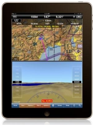
The latest version of WingX Pro7 features new Passive RADAR Altimeter technology for iPad and iPhone. The Passive RADAR Altimeter displays terrain elevation and the aircraft’s approximate AGL; together with Dynamic Terrain Overlays and Synthetic Vision, Hilton Software says WingX Pro7 continues to significantly reduce the risk of Controlled Flight Into Terrain (CFIT). WingX Pro7 Version 6.2 also adds Flight Simulation Mode that enables pilots to pre-fly an entire flight, portion of a flight, or an approach into an airport. Version 6.2’s Moving Map integrates Descent Profile Information that displays descent and landing information to the destination airport or runway touchdown zone.

“We are driven by our desire to increase aviation safety and efficiency," said Hilton Software CEO Dr. Hilton Goldstein. "Our new ‘no hardware, no wires’ Passive RADAR Altimeter solution is revolutionary in mobile aviation computing. WingX Pro7’s new Simulation Mode gives pre-flight a whole new meaning by driving all the pieces of WingX Pro7 including the Moving Map and Synthetic Vision. This enables pilots to simulate an approach into an airport while viewing and interacting with WingX Pro7 as though the approach was actually being flown. Instead of developing a simulator that runs on a desktop, we built flight simulation into the iPad. Another great feature in WingX Pro7 is the addition of Descent Profile Information that not only displays VNAV-like information, but also displays which runway the aircraft is approaching thereby reducing the risk of a runway incursion. We’ve also added tighter integration with Google Earth™ that enables pilots to view their planned route in Google Earth.”

WingX Pro7 Version 6.2 is a free update for registered users and is available now for download from the App Store and iTunes. (Image provided by Hilton Software)

FMI: www.hiltonsoftware.com

Advertisement

More News

Aero-News: Quote of the Day (05.25.25)

“Each Honor Flight mission is a special occasion, but the ability to be a part of EAA AirVenture always creates unforgettable moments. Honoring our local Vietnam veterans out>[...]

Classic Aero-TV: Efficient Versatility -- NASA GL-10 Greased Lightning

From 2015 (YouTube Edition): The Airframes Displayed At AUVSI 2015 Were Quite Innovative It’s common to visualize a small vertical lift UAV as having 4 to 6 propellers, it&rs>[...]

NTSB Prelim: Cessna 525

The Airplane Began A Descent While Still In A Right Turn And Impacted Terrain On March 13, 2025, about 0733 central daylight time, a Cessna 525A airplane, N525CZ, was destroyed whe>[...]

Klyde Morris (05.23.25)

It Looks Like It's Gonna Get A Bit Tight, Klyde FMI: www.klydemorris.com>[...]

Airborne-NextGen 05.20.25: Drone Regs, Zero-Emission Cargo, Door-Dash Drone

Also: Blackhawk’s Replacement, Supersonic Flight, Archer 1Q/25, Long-Range VTOL Program U.S. Secretary of Transportation Sean P. Duffy released an update on progress being ma>[...]

blog comments powered by Disqus


Advertisement

Advertisement

Podcasts

Advertisement

© 2007 - 2025 Web Development & Design by Pauli Systems, LC