GeoEye-1 Captures Inaugural Celebration From Space | Aero-News Network
Aero-News Network
RSS icon RSS feed
podcast icon MP3 podcast
Subscribe Aero-News e-mail Newsletter Subscribe

Airborne Unlimited -- Most Recent Daily Episodes

Episode Date

Airborne-Monday

Airborne-Tuesday

Airborne-Wednesday Airborne-Thursday

Airborne-Friday

Airborne On YouTube

Airborne-Unlimited-05.05.25

Airborne-NextGen-05.06.25

AirborneUnlimited-05.07.25

Airborne-Unlimited-05.01.25

AirborneUnlimited-05.02.25

Wed, Jan 21, 2009

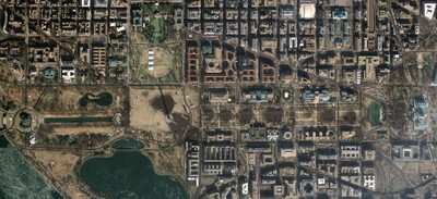
GeoEye-1 Captures Inaugural Celebration From Space

Earth Imaging Satellite Spots Crowds From 423 Miles Above

At 11:19 am EST Tuesday, GeoEye-1, the world's highest resolution commercial Earth-imaging satellite, collected an image over the United States Capitol and the Inauguration of President Barack Obama. The image, taken from 423 miles in space, is the world's highest resolution, color satellite image of the Inaugural celebration.

The image, taken through high, whispy white clouds over Washington DC, shows the monuments along the National Mall and masses of people between the Capitol and the Lincoln Memorial. Among the many interesting features in the image are the clusters of people gathered around large jumbotron screens.

The image was taken by GeoEye's newest satellite, GeoEye-1, as it moved from north to south along the eastern seaboard of the United States traveling at 17,000 mph or about four miles per second.

GeoEye-1 is the world's highest resolution commercial Earth imaging satellite. It is able to discern objects on the ground as small as 0.41-meter or about 16 inches in size, which represents an object about the size of home plate on a baseball diamond. However, due to current U.S licensing restrictions the imagery is re-sampled to half-meter ground resolution.

The satellite is currently in its final stages of check-out and calibration. The 4,300-pound satellite was launched from Vandenberg Air Force Base on September 6, 2008.

GeoEye is making the imagery available at no cost. It is downloadable from the company's website, at the FMI link below.

FMI: www.geoeye.com

Advertisement

More News

ANN's Daily Aero-Term (05.07.25): Terminal Radar Service Area

Terminal Radar Service Area Airspace surrounding designated airports wherein ATC provides radar vectoring, sequencing, and separation on a full-time basis for all IFR and participa>[...]

ANN's Daily Aero-Linx (05.07.25)

Aero Linx: Utah Back Country Pilots Association (UBCP) Through the sharing experiences, the UBCP has built upon a foundation of safe operating practices in some of the most challen>[...]

Classic Aero-TV: Anousheh Ansari -- The Woman Behind The Prize

From 2010 (YouTube Edition): Imagine... Be The Change... Inspire FROM 2010: One of the more unusual phone calls I have ever received occurred a few years ago... from Anousheh Ansar>[...]

NTSB Prelim: Bell 206B

(Pilot) Felt A Shudder And Heard The Engine Sounding Differently, Followed By The Engine Chip Detector Light On April 14, 2025, about 1800 Pacific daylight time, a Bell 206B, N1667>[...]

Airborne-NextGen 05.06.25: AF Uncrewed Fighters, Drones v Planes, Joby Crew Test

Also: AMA Names Tyler Dobbs, More Falcon 9 Ops, Firefly Launch Unsuccessful, Autonomous F-16s The Air Force has begun ground testing a future uncrewed jet design in a milestone tow>[...]

blog comments powered by Disqus


Advertisement

Advertisement

Podcasts

Advertisement

© 2007 - 2025 Web Development & Design by Pauli Systems, LC