Peering Into Emily | Aero-News Network
Aero-News Network
RSS icon RSS feed
podcast icon MP3 podcast
Subscribe Aero-News e-mail Newsletter Subscribe

Airborne Unlimited -- Most Recent Daily Episodes

Episode Date

Airborne-Monday

Airborne-Tuesday

Airborne-Wednesday Airborne-Thursday

Airborne-Friday

Airborne On YouTube

Airborne-Unlimited-10.20.25

AirborneUnlimited-
10.14.25

Airborne-Unlimited-10.15.25

Airborne-NextGen-10.16.25

AirborneUnlimited-10.17.25

Wed, Jul 20, 2005

Peering Into Emily

NASA'S Tropical Cloud Systems And Processes Mission In Costa Rica

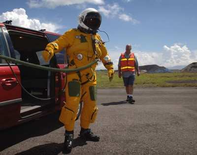
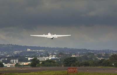
NASA's ER-2  achieved a first July 17 when it flew a series of data-gathering missions above turbulent Hurricane Emily -- the most powerful storm the weather plane and its pilot, NASA pilot David Wright, have ever tackled.

"Hurricane Dennis was much kinder," Wright remarked after his flight. "Emily just didn't want me around."

Wright is NASA's chief pilot for the Tropical Cloud Systems and Processes (TCSP) mission in Costa Rica, the month-long research partnership with the National Oceanic and Atmospheric Administration (NOAA) to study the birthing conditions for tropical storms, hurricanes and related phenomena. NASA and NOAA successfully flew multiple missions July 6 through 9 over Hurricane Dennis, and since July 16 have been tracking Emily -- a Category 4 hurricane -- using some of the world's most sophisticated high-flying and ground-based weather research equipment.

The ER-2 plane overflew Hurricane Emily July 17 around 4 a.m. EDT, heading west-northwest at 17-18 knots. Emily was on track at that time to reach the Yucatan Peninsula of Mexico Monday evening. Emily is an extremely powerful storm, rated a borderline Category 4-5 on the Saffir-Simpson scale, which means the storm is producing sustained maximum wind speeds of approximately 150-155 mph.

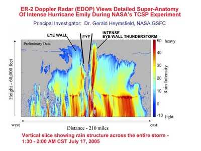
The flight was the first in which the ER-2 has collected data in such an intense tropical system. Flying twice over the eye of the hurricane at 65,000 feet, the plane encountered pronounced turbulence -- an unusual occurrence, especially so early in the hurricane season. The eye-wall clouds powering Emily were extremely energetic and deep. Large amounts of lightning were detected by ER-2 instrumentation, as well as thunderclouds that towered to at least 60,000 feet. NASA instruments recorded unprecedented detail of the hurricane's vertical structure and precipitation levels.

The TCSP mission is sponsored by NASA's Science Mission Directorate. TCSP participants include NOAA, five NASA centers, 10 American universities and partner agencies in Costa Rica. For more information about TCSP, visit:

FMI: www.nasa.gov/vision/earth/lookingatearth/hurricane_2005.html   

Advertisement

More News

Airborne 10.15.25: Phantom 3500 Confounds, Citation CJ3 Gen2 TC, True Blue Power

Also: Kodiak 100 Joins USFS, Innovative Solutions & Support Renamed, Gulfstream Selects Honeywell, Special Olympics Airlift The Phantom 3500 mockup made an appearance where the>[...]

Updated: Gryder Arrested On Gun Charge, Cites ‘Georgia Stand Your Ground’ Law

Incidents Allegedly Occured As Described in Police Report(s) 25-005809 and 25-005818 The name ’Dan Gryder’ is fairly well known to many in aviation.... Whether you like>[...]

Aero-News: Quote of the Day (10.18.25)

“Recent U.S. government policy updates emphasizing investment in domestic drone manufacturing align perfectly with our joint venture objectives, positioning us to meet critic>[...]

ANN's Daily Aero-Term (10.18.25): Final Approach Point

Final Approach Point The point, applicable only to a nonprecision approach with no depicted FAF (such as an on airport VOR), where the aircraft is established inbound on the final >[...]

Classic Aero-TV: Eyeing the Hawk

From 2023 (YouTube Edition): The Best of the Eighties in the Early Twenties It can be argued with confidence that the father of the Ultralight aircraft from which the Light-Sport A>[...]

blog comments powered by Disqus


Advertisement

Advertisement

Podcasts

Advertisement

© 2007 - 2025 Web Development & Design by Pauli Systems, LC