FAA Commissions Surface Surveillance Initiative At SEA-TAC | Aero-News Network
Aero-News Network
RSS icon RSS feed
podcast icon MP3 podcast
Subscribe Aero-News e-mail Newsletter Subscribe

Airborne Unlimited -- Most Recent Daily Episodes

Episode Date

Airborne-Monday

Airborne-Tuesday

Airborne-Wednesday Airborne-Thursday

Airborne-Friday

Airborne On YouTube

Airborne-Unlimited-05.13.24

Airborne-NextGen-05.07.24

Airborne-Unlimited-05.08.24 Airborne-FlightTraining-05.09.24

Airborne-Unlimited-05.10.24

Thu, Oct 20, 2011

FAA Commissions Surface Surveillance Initiative At SEA-TAC

'IntelliDAR' Intelligent Video Platform Will Be Installed

The FAA has commissioned the installation of an "intelligent" video platform developed by Searidge Technologies at the Seattle Tacoma International Airport (SEA) as part of a technology performance assessment led by the University of Illinois Center of Excellence for Airport Technology. The Low-Cost Surface Management Framework (LCSS-F) research program in the FAA's William Hughes Technical Center is examining surveillance technologies for smaller airports.

Searidge, using commercially available sensor-based technologies, will provide low-cost basic ground surveillance capability in the non-movement area, at small to medium sized airports where deployment of Airport Surface Detection Equipment Model X (ASDE-X) technology is not viable. The system will provide airport stakeholders with shared real-time situational awareness of all surface traffic and a comprehensive solution to airport surface movement surveillance encompassing aircraft and vehicle traffic.

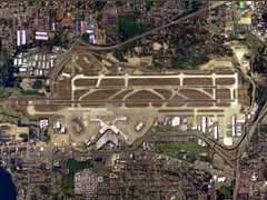
SEA-TAC Aerial Photo

At SEA, Searidge will provide its intelligent video platform "IntelliDAR" to provide a distributed set of non-cooperative sensors (video cameras) that are strategically located to provide surveillance near the terminal. Views from multiple cameras will be fused into a single display, allowing the operator to see all the ground traffic in an intuitive one-look view. The surveillance cameras provide all-weather performance and a long range view giving controllers full visual confirmation of apron and movement areas. Additional system capabilities include real-time positioning, automatic alerting of incursions, live video feeds and archived data for incident review resulting in a more secure and efficient airport surface.

"We are pleased to be involved in another FAA research program. The LCSS framework will highlight the key role intelligent video plays in the market to create a safer and more efficient airport environment," explains Alex Sauriol, vice president, ATM/Airport Technology, Searidge Technologies.

FMI: www.searidgetech.com

Advertisement

More News

Bolen Gives Congress a Rare Thumbs-Up

Aviation Governance Secured...At Least For a While The National Business Aviation Association similarly applauded the passage of the FAA's recent reauthorization, contentedly recou>[...]

The SportPlane Resource Guide RETURNS!!!!

Emphasis On Growing The Future of Aviation Through Concentration on 'AFFORDABLE FLYERS' It's been a number of years since the Latest Edition of Jim Campbell's HUGE SportPlane Resou>[...]

Buying Sprees Continue: Textron eAviation Takes On Amazilia Aerospace

Amazilia Aerospace GmbH, Develops Digital Flight Control, Flight Guidance And Vehicle Management Systems Textron eAviation has acquired substantially all the assets of Amazilia Aer>[...]

Hawker 4000 Bizjets Gain Nav System, Data Link STC

Honeywell's Primus Brings New Tools and Niceties for Hawker Operators Hawker 4000 business jet operators have a new installation on the table, now that the FAA has granted an STC f>[...]

Echodyne Gets BVLOS Waiver for AiRanger Aircraft

Company Celebrates Niche-but-Important Advancement in Industry Standards Echodyne has announced full integration of its proprietary 'EchoFlight' radar into the e American Aerospace>[...]

blog comments powered by Disqus


Advertisement

Advertisement

Podcasts

Advertisement

© 2007 - 2024 Web Development & Design by Pauli Systems, LC