Thu, Oct 20, 2011
'IntelliDAR' Intelligent Video Platform Will Be Installed
 The FAA has commissioned the
installation of an "intelligent" video platform developed by
Searidge Technologies at the Seattle Tacoma International Airport
(SEA) as part of a technology performance assessment led by the
University of Illinois Center of Excellence for Airport Technology.
The Low-Cost Surface Management Framework (LCSS-F) research program
in the FAA's William Hughes Technical Center is examining
surveillance technologies for smaller airports.
The FAA has commissioned the
installation of an "intelligent" video platform developed by
Searidge Technologies at the Seattle Tacoma International Airport
(SEA) as part of a technology performance assessment led by the
University of Illinois Center of Excellence for Airport Technology.
The Low-Cost Surface Management Framework (LCSS-F) research program
in the FAA's William Hughes Technical Center is examining
surveillance technologies for smaller airports.
Searidge, using commercially available sensor-based
technologies, will provide low-cost basic ground surveillance
capability in the non-movement area, at small to medium sized
airports where deployment of Airport Surface Detection Equipment
Model X (ASDE-X) technology is not viable. The system will provide
airport stakeholders with shared real-time situational awareness of
all surface traffic and a comprehensive solution to airport surface
movement surveillance encompassing aircraft and vehicle
traffic.
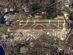
SEA-TAC Aerial Photo
At SEA, Searidge will provide its intelligent video platform
"IntelliDAR" to provide a distributed set of non-cooperative
sensors (video cameras) that are strategically located to provide
surveillance near the terminal. Views from multiple cameras will be
fused into a single display, allowing the operator to see all the
ground traffic in an intuitive one-look view. The surveillance
cameras provide all-weather performance and a long range view
giving controllers full visual confirmation of apron and movement
areas. Additional system capabilities include real-time
positioning, automatic alerting of incursions, live video feeds and
archived data for incident review resulting in a more secure and
efficient airport surface.
"We are pleased to be involved in another FAA research program.
The LCSS framework will highlight the key role intelligent video
plays in the market to create a safer and more efficient airport
environment," explains Alex Sauriol, vice president, ATM/Airport
Technology, Searidge Technologies.
More News
Aero Linx: Model Aeronautical Association of Australia MAAA clubs are about fun flying, camaraderie and community. For over 75 years, the MAAA has been Australia’s largest fl>[...]
Touchdown Zone Lighting Two rows of transverse light bars located symmetrically about the runway centerline normally at 100 foot intervals. The basic system extends 3,000 feet alon>[...]
“Discovery and innovation are central to our mission at Virgin Galactic. We’re excited to build on our successful record of facilitating scientific experiments in subor>[...]
How To Get A Story On Aero-TV News/Feature Programming How do I submit a story idea or lead to Aero-TV? If you would like to submit a story idea or lead, please contact Jim Campbel>[...]
Student Pilot Reported That During Rotation, “All Of A Sudden The Back Of The Plane Kicked To The Right..." Analysis: The student pilot reported that during rotation, “>[...]
 ANN's Daily Aero-Linx (05.02.24)

