RedTail LiDAR Systems Unveils Innovative 3D Mapping Solution | Aero-News Network
Aero-News Network
RSS icon RSS feed
podcast icon MP3 podcast
Subscribe Aero-News e-mail Newsletter Subscribe

Airborne Unlimited -- Most Recent Daily Episodes

Episode Date

Airborne-Monday

Airborne-Tuesday

Airborne-Wednesday Airborne-Thursday

Airborne-Friday

Airborne On YouTube

Airborne-Unlimited-06.17.24

Airborne-NextGen-06.18.24

Airborne-Unlimited-06.12.24 Airborne-FltTraining-06.13.24

Airborne-Unlimited-06.14.24

Fri, Oct 25, 2019

RedTail LiDAR Systems Unveils Innovative 3D Mapping Solution

RTL-400 Introduced At Commercial UAV EXPO As High-Resolution LiDAR System For Small Drones

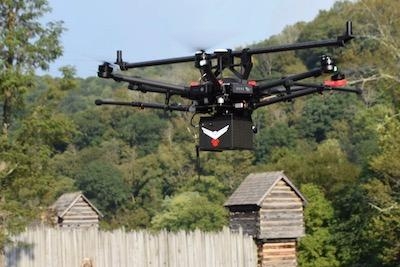
RedTail LiDAR Systems, a division of 4D Tech Solutions, Inc, will introduce the RTL-400 LiDAR mapping system at the Commercial UAV EXPO on October 28th. The RTL-400 was designed specifically to provide high-resolution 3D images of objects on the ground from small drones flying at an altitude up to 400 feet.

Developed with technology licensed from the U.S. Army Research Laboratory (ARL), the RTL-400 provides unique scanning capabilities for a wide range of applications – from precision agriculture to construction site monitoring and management.

The RTL-400 incorporates an innovative microelectromechanical system (MEMS) mirror-based laser scanner that rapidly and evenly distributes laser pulses to the ground, moving side-to-side 400 times each second. This rapid line scan rate, coupled with a laser pulse rate of up to 400,000 pulses per second, yields point clouds that are unprecedented in resolution and density.

Unlike other LiDAR systems, the RTL-400 can be operated in two scanning modes. In addition to the line scan mode, the RTL-400 offers a 30 x 30-degree raster scan mode for "stand and stare" missions. The scanning mode can be selected on the fly, providing drone operators unmatched operational flexibility when planning and flying their missions.

"We are very excited to introduce RedTail LiDAR System's RTL-400. This product has been optimized for use on small drones, providing high-quality point clouds to meet the needs found in the numerous fields where LiDAR is used," said Brad DeRoos, president and CEO of RedTail LiDAR Systems.

Meet the RedTail LiDAR Systems team at the Commercial UAV EXPO in Las Vegas, October 28-30.

(Images provided with RedTail LiDAR Systems news release)

FMI: www.redtaillidar.com

Advertisement

More News

ANN FAQ: Submit a News Story!

Have A Story That NEEDS To Be Featured On Aero-News? Here’s How To Submit A Story To Our Team Some of the greatest new stories ANN has ever covered have been submitted by our>[...]

Aero-News: Quote of the Day (06.12.24)

“The legislation now includes a task force with industry representation ensuring that we have a seat at the table and our voice will be heard as conversations about the futur>[...]

ANN's Daily Aero-Linx (06.12.24)

Aero Linx: Waco Museum The WACO Historical Society, in addition to preserving aviation's past, is also dedicated and actively works to nurture aviation's future through its Learnin>[...]

ANN's Daily Aero-Term (06.12.24): Adcock Range

Adcock Range National low-frequency radio navigation system (c.1930-c.1950) replaced by an omnirange (VOR) system. It consisted of four segmented quadrants broadcasting Morse Code >[...]

Airborne Affordable Flyers 06.06.24: 200th ALTO, Rotax SB, Risen 916iSV

Also: uAvionix AV-Link, Does Simming Make Better Pilots?, World Games, AMA National Fun Fly Czech sportplane manufacturer Direct Fly has finished delivering its 200th ALTO NG, the >[...]

blog comments powered by Disqus


Advertisement

Advertisement

Podcasts

Advertisement

© 2007 - 2024 Web Development & Design by Pauli Systems, LC