 NOTAM Number: FDC 8/3860
Issue Date: April 18, 2008 at 1352 UTC
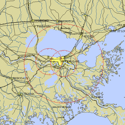
Location: New Orleans, Louisiana
Beginning Date and Time: April 21, 2008 at 1505 UTC
Ending Date and Time: April 22, 2008 at 2010 UTC
Reason for NOTAM: Temporary flight restrictions for VIP (Very
Important Person) Movement
Type: VIP
Replaced NOTAM(s): N/A
Affected Area(s)
Area A
Airspace Definition:
Center: On the HARVEY VORTAC (HRV) 332 degree radial at 5.9
nautical miles. (Latitude: 29º56'20"N, Longitude:
90º03'10"W)
Radius: 30 nautical miles
Altitude: From the surface up to but not including
FL(180)
Effective Date(s):
From April 21, 2008 at 1505 UTC (April 21, 2008 at 1005
CDT)
To April 22, 2008 at 2010 UTC (April 22, 2008 at 1510
CDT)
Area B
Airspace Definition:
Center: On the HARVEY VORTAC (HRV) 297 degree radial at 15.6
nautical miles. (Latitude: 29º58'32"N, Longitude:
90º15'54"W)
Radius: 10 nautical miles
Altitude: From the surface up to but not including
FL(180)
Effective Date(s):
From April 21, 2008 at 1505 UTC (April 21, 2008 at 1005
CDT)
To April 21, 2008 at 1610 UTC (April 21, 2008 at 1110
CDT)

Area C
Airspace Definition:
Center: On the HARVEY VORTAC (HRV) 332 degree radial at 5.9
nautical miles. (Latitude: 29º56'20"N, Longitude:
90º03'10"W)
Radius: 10 nautical miles
Altitude: From the surface up to but not including
FL(180)
Effective Date(s):
From April 21, 2008 at 1525 UTC (April 21, 2008 at 1025
CDT)
To April 22, 2008 at 1950 UTC (April 22, 2008 at 1450
CDT)
Area D
Airspace Definition:
Center: On the HARVEY VORTAC (HRV) 297 degree radial at 15.6
nautical miles. (Latitude: 29º58'32"N, Longitude:
90º15'54"W)
Radius: 10 nautical miles
Altitude: From the surface up to but not including
FL(180)
Effective Date(s):
From April 22, 2008 at 1905 UTC (April 22, 2008 at 1405
CDT)
To April 22, 2008 at 2010 UTC (April 22, 2008 at 1510
CDT)
Operating Restrictions and Requirements
No pilots may operate an aircraft in the areas covered by this
NOTAM (except as described).
Except as specified below and/or unless authorized by the air
traffic security coordinator via the Domestic Events Network
(DEN):
A. All aircraft operations within a 10 NMR area listed above are
prohibited except for:
Approved law enforcement, military aircraft directly supporting
the United States Secret Service (USSS) and the Office of the
President of the United States, approved emergency medical flights,
and regularly scheduled commercial passenger and all-cargo carriers
operating under one of the following TSA-Approved standard security
programs/procedures: aircraft operator standard security program
(AOSSP), full all-cargo standard security program (FACSSP), model
security program (MSP), twelve five standard security program
(TFSSP) all cargo, or all-cargo international security procedure
(ACISP) and are arriving into and/or departing from 14 CFR part 139
airports.
Flight training, practice instrument approaches, aerobatic
flight, glider operations, parachute operations, ultralight, hang
gliding, balloon operations, agriculture/crop dusting, animal
population control flight operations, banner towing operations,
model aircraft operations, model rocketry, and unmanned aerial
systems (UAS) are not authorized.
For operations within the TFR, all emergency/life saving flight
(medical/law enforcement/firefighting) operations must coordinate
in advance with the USSS at 504-471-4359 to avoid potential
delays.
B. Within the airspace between 10 NMR and 30 NMR listed
above:
All aircraft entering or exiting the 30 NMR TFR must be on an
active IFR or VFR flight plan with a discrete code assigned by an
Air Traffic Control (ATC) facility. Aircraft must be squawking the
discrete code prior to departure and at all times while in the
TFR.
All aircraft entering or exiting the 30 NMR TFR must remain in
two-way radio communications with ATC.
ALL AIRCRAFT OPERATING BETWEEN 10 NMR AND 30 NMR LISTED ABOVE
AND OPERATING AT ALTITUDES OF UP TO BUT NOT INCLUDING FL180 ARE
LIMITED TO AIRCRAFT ARRIVING OR DEPARTING LOCAL AIRFIELDS AND ATC
MAY AUTHORIZE TRANSIT OPERATIONS. AIRCRAFT MAY NOT LOITER.
Flight training, practice instrument approaches, aerobatic
flight, glider operations, parachute operations, ultralight, hang
gliding, balloon operations, agriculture/crop dusting, animal
population control flight operations, banner towing operations,
model aircraft operations, model rocketry, and unmanned aerial
systems (UAS) are not authorized.
All USSS cleared aircraft operators based in the area should
notify the USSS prior to their departure.
For operations within the TFR, all emergency/life saving flight
(medical/law enforcement/firefighting) operations must coordinate
in advance with the USSS at 504-471-4359 to avoid potential
delays.
C. FAA recommends that all aircraft operators check NOTAMS
frequently for possible changes to this TFR prior to operations
within this region.
Other Information:
ARTCC: ZHU - Houston Center
Authority: Title 14 CFR section 91.141
FMI: www.tfr.faa.gov,
Depicted TFR data may not be a complete listing. Pilots should not
use the information on this website for flight planning purposes.
For the latest information, call your local Flight Service Station
at 1-800-WX-BRIEF.
 ANN's Daily Aero-Linx (06.29.25)
 ANN's Daily Aero-Term (06.29.25): Gross Navigation Error (GNE)
 Classic Aero-TV: Anticipating Futurespace - Blue Origin Visits Airventure 2017
 NTSB Final Report: Cirrus SR22
 Airborne Affordable Flyers 06.26.25: PA18 Upgrades, Delta Force, Rhinebeck


