Best of Osh25: Bringing Sectionals to Life as Interactive Artwork | Aero-News Network
Aero-News Network
RSS icon RSS feed
podcast icon MP3 podcast
Subscribe Aero-News e-mail Newsletter Subscribe

Airborne Unlimited -- Most Recent Daily Episodes

Episode Date

Airborne-Monday

Airborne-Tuesday

Airborne-Wednesday Airborne-Thursday

Airborne-Friday

Airborne On YouTube

Airborne-Unlimited-11.24.25

AirborneNextGen-
11.18.25

Airborne-Unlimited-11.19.25

Airborne-AffordableFlyers-11.20.25

AirborneUnlimited-11.21.25

LIVE MOSAIC Town Hall (Archived): www.airborne-live.net

Mon, Jul 28, 2025

Best of Osh25: Bringing Sectionals to Life as Interactive Artwork

METAR Maps Provides Real-Time Weather Data in a Creative Wall Piece

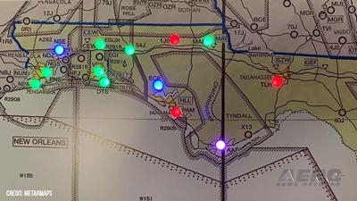
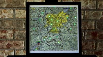
METAR Maps was a design from a pilot’s perspective to provide the ease of looking at the weather at a glance. Founded by Richard Freilich, an aviator, aircraft owner, and retired tech professional, the idea is to blend the precision of aviation data with the elegance of living art. After 8 years in business and over 3,000 pieces sold, METAR Maps has become a beautiful piece of art in hangars, homes, and offices across the country.

Each map is a live visual display of real-time aviation weather, showing flight categories, clouds, and lightning with subtle flashes of light. It transforms traditional aviation sectionals into stunning wall art already framed, behind non-reflective glass, and available in a range of sizes.

Richard’s background in technology plays a key role in the design. Rather than requiring an app, METAR Maps connects securely through a web interface on your phone or computer, intentionally designed to keep your data safe and your experience stress-free.

Richard says he has renewed passion every year when customers come to see him at Oshkosh and “gush”. Customers don’t just use these maps; they love them. Many say they look at them every single day. They spark conversations, bring joy, and reignite a passion for flight and weather. As the years go on, so does the enthusiasm from new and returning customers alike.

Today, the website features over 100 unique map options, with even more available that haven’t been released. They vary in price, but they are all pretty cool. Each one is a piece of living art, functional, beautiful, and made for aviators by someone who understands aviation and technology. Version 4 has many improvements, including sunrise and sunset with temperature.

FMI: www.metarmaps.com

Advertisement

More News

ANN's Daily Aero-Linx (11.25.25)

Aero Linx: Vintage Sailplane Association The purpose of the Vintage Sailplane Association (VSA) is to promote the acquisition, restoration and flying of vintage sailplanes by its m>[...]

NTSB Final Report: Glasair GlaStar

Smoke Began Entering The Cockpit During The Landing Flare, And Then The Pilot Noticed Flames... Analysis: The pilot reported that about 30 minutes into the local flight, he heard s>[...]

ANN FAQ: Turn On Post Notifications

Make Sure You NEVER Miss A New Story From Aero-News Network Do you ever feel like you never see posts from a certain person or page on Facebook or Instagram? Here’s how you c>[...]

Classic Aero-TV: Red Tail Project Update – Taking the Mission to the People

From 2010 (YouTube Edition): The Red Tail Project Continues Effort Towards ‘Rise Above Program’ The Red Tail Project is a true example of this unbreakable spirit. In 20>[...]

Airborne 11.24.25: ANN's 30th!, Starship’s V3 Booster Boom, Earhart Records

Also: 1st-Ever Space Crime Was a Fraud, IAE Buys Diamonds, Kennon Bows Out, Perseverance Rover An interesting moment came about this past Sunday as ANN CEO, Jim Campbell, noted tha>[...]

blog comments powered by Disqus


Advertisement

Advertisement

Podcasts

Advertisement

© 2007 - 2025 Web Development & Design by Pauli Systems, LC