Multiple Sorties Flown Into Storms Over The Pacific And Atlantic Oceans
It's been a busy two weeks for the Air Force Reserve's Hurricane Hunters, the 53rd Weather Reconnaissance Squadron flew their last of 15 missions into Hurricane Ana in the Pacific Oct. 20, while gathering weather data for the Central Pacific Hurricane Center.
On the other side of the globe, the hunters wrapped up a week-long deployment to St. Croix, U.S. Virgin Islands, flying their last Hurricane Gonzalo mission Oct. 16, in the Atlantic.
It's not unusual to have storms this late in the season, said Maj. Jon Brady, a 53rd WRS aerial reconnaissance weather officer.
"The peak of the season is in September, but there is a historical trend for it to re-spike in October. Some of the biggest storms and hybrid storms form in October," he said, adding that Hurricane Sandy struck in October and was the deadliest and most destructive hurricane of the 2012 Atlantic hurricane season.
What is extremely rare is to have a third hurricane hit Hawaii in the same season, Brady said, who added the Hurricane Hunters only deploy to the Central Pacific when Hawaii is threatened. Hawaii has been hit by five hurricanes since 1952, until this year the last hurricane to strike the islands was Hurricane Iniki in 1992.
The Hurricane Hunters deployed to Joint Base Pearl Harbor-Hickam, Hawaii for the second time this season and began flying missions into Ana Oct. 16. The unit deployed to Hawaii in August to fly Hurricanes Iselle and Julio. The last time the squadron deployed to Hawaii was in 2007, for Hurricane Flossie, which wasn't a direct hit and brought light damage to the islands.
"The Pacific is much warmer than normal," Brady said. "This is indicative of an El Nino, which gets the water much hotter than normal and causes more storms to form in the Pacific than the Atlantic, which was the case this year."
Ana, the 21st named storm in the Pacific, became a Hurricane Oct. 18, passing to the south of the Hawaiian Islands, but caused severe weather and heavy rains during the weekend.
The National Weather Service's Central Pacific Hurricane Center in Honolulu and the National Hurricane Center in Miami rely on satellite images and Doppler radar for their forecasts models. The data the hurricane hunters provide improves the accuracy of the track forecast by 15 to 20 percent, said Dennis Feltgen, NHC public affairs officer.
"When you look at the satellite imagery you are not sure what is going on inside the storm. Sending the Hurricane Hunters into a storm is the equivalent of going to the doctor's office and getting an MRI," he said.
To gather this data, aircrews fly through the eye of a storm four to six times to locate the low-pressure center and circulation of the storm. During each pass through the eye, they release a dropsonde, which collects weather data on its descent to the ocean surface, measuring wind speed and direction, temperature, dew point and pressure. During storm flights, the aircrews transmit weather data via satellite communication every 10 minutes to the NHC or CPHC providing forecasters vital data on a storm's intensity and direction, assisting them with their forecasts and storm warnings.
The NHC used this data earlier in the month for forecast and storm warnings for the Caribbean Islands impacted by Hurricane Gonzalo.
The squadron deployed to the Henry E. Rohlsen Airport in St. Croix Oct. 10 to track the weather system that formed into Tropical Storm Gonzalo Oct. 12 and became a hurricane Oct. 14.
As the system made its way through the Caribbean Islands, the deployed aircrews relocated to Homestead Air Reserve Base, Florida, Oct. 13. Aircrews continued around-the-clock reconnaissance of the hurricane until Oct. 16. They flew out of Homestead and Keesler Air Force Base, Mississippi. The squadron flew 15 missions gathering data on the storm, which at its strongest was a Category 4, and caused damage in Antigua, Saint Martin and Bermuda. The storm struck Bermuda Oct. 18 as a Category 2. The storm's remnants hit the United Kingdom late Monday.
While crews recover from Hurricanes Ana and Gonzalo, the squadron is moving on to the next storm. The Hurricane Hunters are flying a low level investigation mission today on a storm forming in the Gulf of Mexico near the Bay of Campeche west of Yucatan.
ANN Salutes Maj. Marnee A.C. Losurdo, 403rd Wing Public Affairs
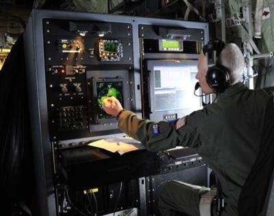
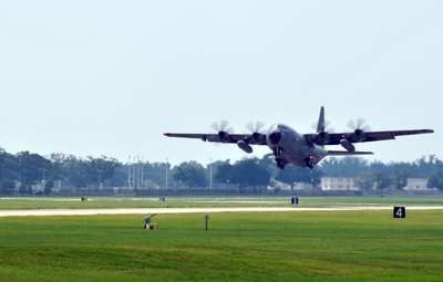
(Image provided by the U.S. Air Force. Top: Lt. Col. Jon Talbot points to the eye of Hurricane Julio during a hurricane flight off the coast of Hawaii Aug. 9, 2014.Talbot is a 53rd Weather Reconnaissance Squadron aerial reconnaissance weather officer. Bottom image from file)
 Classic Aero-TV: Pure Aerial Precision - The Snowbirds at AirVenture 2016

