Hurricane Henri Is Approaching the Northeast | Aero-News Network
Aero-News Network
RSS icon RSS feed
podcast icon MP3 podcast
Subscribe Aero-News e-mail Newsletter Subscribe

Airborne Unlimited -- Most Recent Daily Episodes

Episode Date

Airborne-Monday

Airborne-Tuesday

Airborne-Wednesday Airborne-Thursday

Airborne-Friday

Airborne On YouTube

Airborne-Unlimited-10.20.25

AirborneUnlimited-
10.14.25

Airborne-Unlimited-10.15.25

Airborne-NextGen-10.16.25

AirborneUnlimited-10.17.25

Sun, Aug 22, 2021

Hurricane Henri Is Approaching the Northeast

NYC Declares State Of Emergency

Keep your eyes on the weather this weekend, if you are flying in the Northeast, as Hurricane Henri approaches the area.

Henri was upgraded from a tropical storm to a hurricane on Saturday. The storm brings with it heavy winds, rain, and storm surge. The hurricane is likely to make landfall between Long Island and Southern New England Sunday.
The National Weather Service reports the most likely time of arrival of tropical-storm-force winds for southern New England to be Sunday morning.

New York City Mayor Bill de Blasio declared a state of emergency Saturday afternoon ahead of the storm. Residents of the Northeast should keep in mind that the area is already deeply saturated and a call has been put out to be aware of potential flooding. Henri is a slow-moving system that is set to leave a lot of rain in its path.

Narragansett Bay and the south coasts of RI and MA are most likely to be affected by the surge flooding, while CT and western and central MA are most at risk for rainfall flooding.

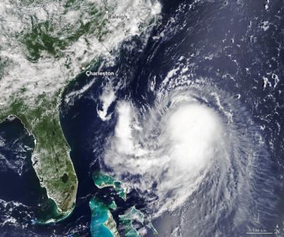
With this storm system, New England is facing its first direct hurricane landfall in thirty years. According to an image acquired from NASA’s Terra satellite at 11:45 AM ET on August 20, 2021, Henri was located about 400 miles southeast of Charleston, SC moving northwest. Sustained winds measured 65 miles per hour, 9 miles short of a category-1 hurricane.

As of 17:00 ET Saturday, Hurricane Henri was located 335 miles south of Montauk Point, NY with 75mph winds and moving north at 18 mph.

FWI: www.weather.gov/box/tropical

Advertisement

More News

Airborne 10.15.25: Phantom 3500 Confounds, Citation CJ3 Gen2 TC, True Blue Power

Also: Kodiak 100 Joins USFS, Innovative Solutions & Support Renamed, Gulfstream Selects Honeywell, Special Olympics Airlift The Phantom 3500 mockup made an appearance where the>[...]

Airborne 10.14.25: Laser Threat, VeriJet BK, Duffy Threatens Problem Controllers

Also: USAF Pilots, Atlanta Tower Evac, Archer Spotlight Dissipates, Hop-A-Jet Sues A social-media call for people to point lasers at aircraft flying over Portland’s ICE facil>[...]

Aero-News: Quote of the Day (10.20.25)

“We developed this prototype from concept to reality in under a year. The U-Hawk continues the Black Hawk legacy of being the world’s premier utility aircraft and opens>[...]

ANN's Daily Aero-Term (10.20.25): Flameout Pattern

Flameout Pattern An approach normally conducted by a single-engine military aircraft experiencing loss or anticipating loss of engine power or control. The standard overhead approa>[...]

NTSB Final Report: Schweizer SGS 2-33A

Student Pilot’s Failure To Maintain Airspeed And Altitude Resulting In A Collision With The Ground During The Base To Final Turn Analysis: The solo student pilot reported she>[...]

blog comments powered by Disqus


Advertisement

Advertisement

Podcasts

Advertisement

© 2007 - 2025 Web Development & Design by Pauli Systems, LC