Eyes Over The Ocean | Aero-News Network
Aero-News Network
RSS icon RSS feed
podcast icon MP3 podcast
Subscribe Aero-News e-mail Newsletter Subscribe

Airborne Unlimited -- Most Recent Daily Episodes

Episode Date

Airborne-Monday

Airborne-Tuesday

Airborne-Wednesday Airborne-Thursday

Airborne-Friday

Airborne On YouTube

Airborne-Unlimited-11.10.25

AirborneNextGen-
11.11.25

Airborne-Unlimited-11.12.25

Airborne-Unlimited-11.06.25

AirborneUnlimited-11.07.25

LIVE MOSAIC Town Hall (Archived): www.airborne-live.net

Tue, May 11, 2004

Eyes Over The Ocean

And Now They Can See Better Than Ever

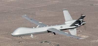
Raytheon Company has successfully integrated and demonstrated its SeaVue maritime surveillance radar and AAS-52 Multi-spectral Targeting System (MTS-A) aboard a General Atomics Aeronautical Systems Mariner unmanned aerial vehicle (UAV), a derivative of the Generals Atomics Predator B UAV.

"The successful April flight demonstration from El Mirage (CA), is a perfect example of what a motivated team can accomplish," said Jack Kelble, presiadent of Raytheon Space and Airborne Systems. "In order to meet an important demonstration request, we installed and integrated the SeaVue and MTS-A mission systems, and then performed the necessary flight verification tests in only three weeks. This is a remarkable engineering achievement."

In addition to demonstrating the Mariner UAV's performance and operational flexibility at various altitudes, the flight highlighted the sensors' combined maritime surveillance capabilities and network connectivity when operating together on one platform. This flight demonstrated many of the capabilities outlined in the U.S. Navy's Broad Area Maritime Surveillance requirement.

The SeaVue family of radars is designed to detect small maritime targets in high seas and provide superior maritime situational awareness. The system's flexible architecture enables it to meet a wide variety of surveillance requirements and support multiple missions. Depending on the configuration, typical missions include maritime surface search and target tracking, ship imaging and classification, overland mapping, search and rescue, weather avoidance and navigation, harbor and economic zone surveillance, and environmental monitoring such as oil spill detection and ice flow mapping. SeaVue was designed as a light weight, low cost, surveillance radar that can be easily installed on smaller aircraft, helicopters, and unmanned vehicles. To date, more than 100 SeaVue radar systems are in operation around the world.

The AAS-52 MTS-A is a multi-use electro-optical, infrared, and laser detecting-ranging-tracking set, developed and produced for use in military systems. Using state-of-the-art digital architecture, this advanced electro-optical/infrared (EO/IR) system provides long-range surveillance, target acquisition, tracking, range finding, and laser designation for all tri-service and NATO laser-guided munitions.

FMI: www.raytheon.com, www.uav.com

Advertisement

More News

ANN FAQ: Contributing To Aero-TV

How To Get A Story On Aero-TV News/Feature Programming How do I submit a story idea or lead to Aero-TV? If you would like to submit a story idea or lead, please contact Jim Campbel>[...]

Classic Aero-TV: Bob Hoover At Airventure -- Flight Test and Military Service

From 2011 (YouTube Edition): Aviation's Greatest Living Legend Talks About His Life In Aviation (Part 5, Final) ANN is pleased to offer you yet another snippet from the public conv>[...]

Aero-News: Quote of the Day (11.12.25)

“All Air Traffic Controllers must get back to work, NOW!!! Anyone who doesn’t will be substantially ‘docked. For those Air Traffic Controllers who were GREAT PATR>[...]

ANN's Daily Aero-Linx (11.12.25)

Aero Linx: American Navion Society Welcome to the American Navion Society. Your society is here to support the Navion community. We are your source of technical and operating infor>[...]

ANN's Daily Aero-Term (11.12.25): Glideslope Intercept Altitude

Glideslope Intercept Altitude The published minimum altitude to intercept the glideslope in the intermediate segment of an instrument approach. Government charts use the lightning >[...]

blog comments powered by Disqus


Advertisement

Advertisement

Podcasts

Advertisement

© 2007 - 2025 Web Development & Design by Pauli Systems, LC