Will Monitor Weather, Climate Patterns To Better-Predict
Changes
Though overshadowed by NASA's groundbreaking announcement last
week the Mars Phoenix probe had unearthed evidence of ice on the
Red Planet, the space agency achieved another significant
accomplishment Friday -- and this one was a lot closer to home.
A new NASA-French space agency oceanography satellite launched
Friday from Vandenberg Air Force Base, CA on a globe-circling
voyage to continue charting sea level, a vital indicator of global
climate change. The mission will return a vast amount of new data
that will improve weather, climate and ocean forecasts.
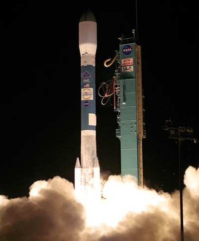
With a thunderous roar and fiery glow, the Ocean Surface
Topography Mission/Jason 2 satellite arced through the blackness of
an early central coastal California morning at 0046 PDT, climbing
into space atop a Delta II rocket. Fifty-five minutes later,
OSTM/Jason 2 separated from the rocket's second stage, and then
unfurled its twin sets of solar arrays. Ground controllers
successfully acquired the spacecraft's signals. Initial telemetry
reports show it to be in excellent health.
"Sea-level measurements from space have come of age," said
Michael Freilich, director of the Earth Science Division in NASA's
Science Mission Directorate, Washington. "Precision measurements
from this mission will improve our knowledge of global and regional
sea-level changes and enable more accurate weather, ocean and
climate forecasts."
Measurements of sea-surface height, or ocean surface topography,
reveal the speed and direction of ocean currents and tell
scientists how much of the sun's energy is stored by the ocean.
Combining ocean current and heat storage data is key to
understanding global climate variations. OSTM/Jason 2's expected
lifetime of at least three years will extend into the next decade
the continuous record of these data started in 1992 by NASA and the
French space agency Centre National d'Etudes Spatiales, or CNES,
with the TOPEX/Poseidon mission. The data collection was continued
by the two agencies on Jason 1 in 2001.
The mission culminates more than three decades of research by
NASA and CNES in this field. This expertise will be passed on to
the world's weather and environmental forecasting agencies, which
will be responsible for collecting the data. The involvement of the
National Oceanic and Atmospheric Administration (NOAA) and the
European Organisation for the Exploitation of Meteorological
Satellites (EUMETSAT) as mission partners on OSTM/Jason 2 helps
establish this proven research capability as a valuable tool for
use in everyday applications.
OSTM/Jason 2's five primary instruments are improved versions of
those flying on Jason 1. These technological advances will allow
scientists to monitor conditions in ocean coastal regions -- home
to about half of Earth's population. Compared with Jason 1
measurements, OSTM/Jason 2 will have substantially increased
accuracy and provide data to within 25 kilometers (15 miles) of
coastlines, nearly 50 percent closer to shore than in the past.
Such improvements will be welcome news for all those making their
living on the sea, from sailors and fishermen to workers in
offshore industries.
NOAA will use the improved data to better predict hurricane
intensity, which is directly affected by the amount of heat stored
in the upper ocean.
 OSH25 Day Four Redux: Spirit SE-1!, H55 eFlyer, King Schools