GOES-17 Mishap Investigation Board Study Completed | Aero-News Network
Aero-News Network
RSS icon RSS feed
podcast icon MP3 podcast
Subscribe Aero-News e-mail Newsletter Subscribe

Airborne Unlimited -- Most Recent Daily Episodes

Episode Date

Airborne-Monday

Airborne-Tuesday

Airborne-Wednesday Airborne-Thursday

Airborne-Friday

Airborne On YouTube

Airborne-Unlimited-11.10.25

AirborneNextGen-
11.11.25

Airborne-Unlimited-11.12.25

Airborne-Unlimited-11.06.25

AirborneUnlimited-11.07.25

LIVE MOSAIC Town Hall (Archived): www.airborne-live.net

Wed, Aug 07, 2019

GOES-17 Mishap Investigation Board Study Completed

Most Likely Cause Of The ABI Cooling Issue Is A Blockage In The Instrument’s Loop Heat Pipes

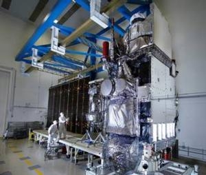
A Mishap Investigation Board appointed by NASA and the National Oceanic and Atmospheric Administration (NOAA) has identified the most likely cause for an instrument issue aboard NOAA’s Geostationary Operational Environmental Satellite (GOES)-17 satellite that launched March 1, 2018 from Cape Canaveral Air Force Station in Florida.

During postlaunch testing of the satellite’s Advanced Baseline Imager (ABI), teams discovered the instrument’s infrared detectors could not be maintained at the required temperatures during some orbital conditions, which resulted in a partial loss of three of the instruments 16 bands during certain times of the year.

The ABI is GOES-17’s primary instrument for imaging Earth’s weather, oceans, and environment. It views the Earth with 16 spectral bands including two visible, four near-infrared, and 10 infrared channels.

The mishap board was tasked with gathering and analyzing information, and identifying the proximate causes, root causes, and contributing factors related to the ABI performance issues. It concluded the most likely cause of the ABI cooling issue is a blockage in the instrument’s loop heat pipes, which transfer heat from the ABI electronics to its radiator. The blockage restricted the flow of coolant in the loop heat pipes, causing the ABI to overheat and reducing the sensitivity of infrared sensors.

NOAA and NASA have adjusted the instrument operations, and are working to improve the quality of the data in order to reduce the impact of the cooling issue.

GOES-17, in the GOES-West position, is helping forecasters track weather from torrential rain events to wildfires and other environmental hazards throughout the U.S. western region, including California, Alaska and Hawaii. Also, GOES-17 is monitoring typhoons in the eastern Pacific Ocean, including Hawaii.

(Image provided with NASA news release)

FMI: www.nasa.gov/reports

Advertisement

More News

NBAA Responds To GA/BA Operational Restrictions

Bolen Issues Statement Reinforcing Need To Reopen Government The National Business Aviation Association’s President and CEO issued the statement below in response to further >[...]

Boeing Deliveries Surge to Pre-Pandemic Levels

Output May Reach Its Best Since 2018 Despite Trailing Behind Airbus Boeing delivered 53 jets in October, bringing its 2025 total to 493 aircraft and marking its strongest output si>[...]

Spirit Forecasts Financial Turbulence

Low-Cost Airline Admits “Substantial Doubt” It Can Stay Airborne Spirit Airlines has once again found itself in financial trouble, this time less than a year after clai>[...]

Singapore Adds a Price Tag to Going Green

Travelers Leaving Changi Will Soon Pay for Sustainable Fuel Starting April 2026, passengers flying out of Singapore will find a new fee tucked into their tickets: a Sustainable Avi>[...]

NTSB Final Report: Arlie L Raber III Challenger 1

Pilot Was Having Difficulty Controlling The Airplane’S Rudder Pedals Due To His Physical Stature Analysis: The pilot was having difficulty controlling the airplane’s ru>[...]

blog comments powered by Disqus


Advertisement

Advertisement

Podcasts

Advertisement

© 2007 - 2025 Web Development & Design by Pauli Systems, LC