The View From Up Here | Aero-News Network
Aero-News Network
RSS icon RSS feed
podcast icon MP3 podcast
Subscribe Aero-News e-mail Newsletter Subscribe

Airborne Unlimited -- Most Recent Daily Episodes

Episode Date

Airborne-Monday

Airborne-Tuesday

Airborne-Wednesday Airborne-Thursday

Airborne-Friday

Airborne On YouTube

Airborne-Unlimited-10.27.25

AirborneNextGen-
10.28.25

Airborne-Unlimited-10.29.25

Airborne-Unlimited-10.30.25

AirborneUnlimited-10.17.25

Thu, May 13, 2004

The View From Up Here

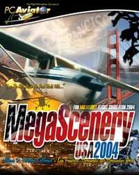
True To Life Scenery Of "The City By The Bay" For Microsoft Flight Simulator

MegaScenery publisher, PC Aviator, today announced that the third volume of MegaScenery – Northern California, featuring San Francisco, Sacramento and 38,000 square miles of surrounding countryside has gone gold and is scheduled for release on 7 June 2004.

Bigger, better and prettier than previous MegaScenery areas, "MegaScenery Volume 3: Northern California" has been recreated from 5 meter satellite imagery and puts Microsoft Flight Simulator pilots up there in the skies above this diversely picturesque region of the United States.

San Francisco, Oakland, Sacramento, down to Monterey bay and inland to the W120.5 longitudinal line…. and everything else in between: Flight Simulator pilots will be able to take to the skies and navigate this expansive scenery identifying everything down to individual rooftops on houses.

Aerosoft Australia, developers of MegaScenery, have continued to enhance MegaScenery technology and this volume comes with even further improved night scenery. 

It also incorporates high-resolution 30 meter terrain mesh for elevation data resulting in even more realistic mountains and valleys.

While there are other photo-realistic scenery products available only MegaScenery provides complete night scenery for the entire area so users get both a day and night VFR flying experience.

Just like the previous titles and all future MegaScenery titles, the Northern California package comes with all of the real world aeronautical charts required to fly the scenery [like a pilot] and to identify all of the major landmarks the scenery contains.

FMI: http://www.megascenery.com

Advertisement

More News

A ‘Crazy’ Tesla Flying Car is Coming

Musk Claims the Tech Could Be Unveiled Within a Couple of Months Elon Musk is once again promising the impossible…this time, in the form of a Tesla that flies. Speaking on T>[...]

ANN's Daily Aero-Term (11.xx.25): NonApproach Control Tower

NonApproach Control Tower Authorizes aircraft to land or takeoff at the airport controlled by the tower or to transit the Class D airspace. The primary function of a nonapproach co>[...]

Aero-News: Quote of the Day (11.01.25)

"It was pretty dang cool to be in a tube-and-fabric bush plane that high, and it was surreal hearing airline pilots over ATC wondering what a Cub was doing up there. The UL is trul>[...]

ANN's Daily Aero-Linx (11.01.25)

Aero Linx: Lake Amphibian Club Over the years the cost of a new Skimmer or Lake went from about $16,000 to over $500,000 for many reasons. Sales of Renegades have been very sparse >[...]

Classic Aero-TV: EAA Introduces Angle of Attack Training

From 2024 (YouTube Edition): Clinic Aimed to Promote Safe Aircraft Control The EAA Pilot Proficiency Center hosted an angle of attack (AOA) training clinic during the 2024 Oshkosh >[...]

blog comments powered by Disqus


Advertisement

Advertisement

Podcasts

Advertisement

© 2007 - 2025 Web Development & Design by Pauli Systems, LC