ERAU Uses UAVs, AI For Lake Beresford Vegetation Survey | Aero-News Network
Aero-News Network
RSS icon RSS feed
podcast icon MP3 podcast
Subscribe Aero-News e-mail Newsletter Subscribe

Airborne Unlimited -- Most Recent Daily Episodes

Episode Date

Airborne-Monday

Airborne-Tuesday

Airborne-Wednesday Airborne-Thursday

Airborne-Friday

Airborne On YouTube

Airborne-Unlimited-08.18.25

Airborne-NextGen-08.12.25

AirborneUnlimited-08.13.25

Airborne-AffordableFlyers-08.14.25

AirborneUnlimited-08.15.25

Sun, Aug 24, 2025

ERAU Uses UAVs, AI For Lake Beresford Vegetation Survey

Collab With Stetson University To Get Handle On Lake’s Health

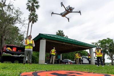
Researchers at Embry-Riddle Aeronautical University are collaborating with Stetson University’s Institute of Water and Environmental Resilience using drones to capture aerial imagery of aquatic vegetation that will be used to train AI models to automatically classify plant life and examine the health of waterways such as lakes, rivers, and other bodies of water.

The project’s UAVs are equipped with a variety of cameras and sensors to find and collect images of aquatic plants on the shoreline of Lake Beresford just west of DeLand, Florida.

Dr. Dan Macchiarella, professor in the Department of Aeronautical Science said, “Our flight missions have been aimed at gathering images to train the AI. We started with water lettuce, but we are looking at expanding out beyond that.”

Water lettuce is an aggressive invasive weed that can rapidly overrun rivers and lakes, and crowd out native plants and animals. It forms dense mats that can also restrict the flow of water, creating conditions hostile to animal life.

The data gathered from the project will also be used to evaluate and assess the diversity and number of plants that provide understanding of the health of the body of water. Multispectral imaging is used to detect light bands to determine plant health. Thermal sensors are used to display data on temperature differences in Lake Beresford.

Macchiarella explained, “There is a theory that there is a spring in that lake. We’re looking if we can see a temperature difference to indicate the location of a spring in the lake because a spring is always 72 degrees.”

The research is funded by the National Science Foundation and the National Oceanic and Atmospheric Administration.

FMI:  daytonabeach.erau.edu/ , www.stetson.edu/

Advertisement

More News

ANN's Daily Aero-Term (08.21.25): Localizer Performance With Vertical Guidance

Localizer Performance With Vertical Guidance (LPV) A type of approach with vertical guidance (APV) based on WAAS, published on RNAV (GPS) approach charts. This procedure takes adva>[...]

NTSB Final Report: Rutan Long-EZ

(Pilot) Heard A Loud “Bang” As The Nose Gear Collapsed And The Nose Continued To Settle, Sliding Down The Runway Surface Analysis: The pilot stated that when he touched>[...]

Classic Aero-TV: Living the Dream – ANG’s John Klatt Performs at EAA

From 2010 (YouTube Edition): Aero-TV Takes to the Skies Alongside ANG’s John Klatt John Klatt is a man who truly lives and breathes aviation. As the pilot for John Klatt Airs>[...]

Airborne 08.18.25: Unlimiteds Cancel NCAR25, Starship 10, No ATC Privatization

Also: Solar-Powered Record, IAM Appeals, Airshow Pilot Lost, Air India Flamed The Unlimited Class recently confirmed that it would be withdrawing from this year’s National Ch>[...]

Airborne Affordable Flyers 08.14.25: Affordable Flying Expo, RV15 Kit, Spirit V2

Also: iFly EFB, World Skydiving Day, Air Avionics, Two New CubCrafters Kits After a master strategy meeting this past week on the grounds of the Sun n Fun Aerospace Expo campus, de>[...]

blog comments powered by Disqus


Advertisement

Advertisement

Podcasts

Advertisement

© 2007 - 2025 Web Development & Design by Pauli Systems, LC