Curiosity Adds Reverse Driving For Wheel Protection | Aero-News Network
Aero-News Network
RSS icon RSS feed
podcast icon MP3 podcast
Subscribe Aero-News e-mail Newsletter Subscribe

Airborne Unlimited -- Most Recent Daily Episodes

Episode Date

Airborne-Monday

Airborne-Tuesday

Airborne-Wednesday Airborne-Thursday

Airborne-Friday

Airborne On YouTube

Airborne-Unlimited-07.14.25

Airborne-NextGen-07.15.25

AirborneUnlimited-07.16.25

Airborne-FlightTraining-07.17.25

AirborneUnlimited-07.11.25

Fri, Feb 21, 2014

Curiosity Adds Reverse Driving For Wheel Protection

Adds New Functionality To The Rover's Toolkit

Terrain that NASA's Curiosity Mars rover is now crossing is as smooth as team members had anticipated based on earlier images from orbit. On Tuesday, Feb. 18, the rover covered 329 feet, the mission's first long trek that used reverse driving and its farthest one-day advance of any kind in more than three months.

The reverse drive validated feasibility of a technique developed with testing on Earth to lessen damage to Curiosity's wheels when driving over terrain studded with sharp rocks. However, Tuesday's drive took the rover over more benign ground. "We wanted to have backwards driving in our validated toolkit because there will be parts of our route that will be more challenging," said Curiosity Project Manager Jim Erickson of NASA's Jet Propulsion Laboratory, Pasadena, CA.

The rover team used images taken from orbit to reassess possible routes, after detecting in late 2013 that holes in the vehicle's aluminum wheels were accumulating faster than anticipated. Getting to the chosen route, which appeared to be less hazardous for the wheels, required crossing a 3-foot-tall (1-meter-tall) dune. Curiosity crossed the dune on Feb. 9.

Erickson said, "After we got over the dune, we began driving in terrain that looks like what we expected based on the orbital data. There are fewer sharp rocks, many of them are loose, and in most places there's a little bit of sand cushioning the vehicle."

The mission's destinations remain the same: a science waypoint first and then the long-term goal of investigating the lower slopes of Mount Sharp, where water-related minerals have been detected from orbit.

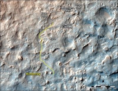
The science waypoint, which may be where Curiosity next uses its sample-collecting drill, is an intersection of different rock layers about two-thirds of a mile ahead on the planned route. This location, formerly called KMS-9 from when it was one of many waypoint candidates, is now called "Kimberley," for the geological mapping quadrant that contains it. The mapping quadrant was named for the northwestern Australia region with very old rocks.

While the rover is headed for the Kimberley waypoint and during the time it spends doing science investigations there, the team will use orbital imagery to choose a path for continuing toward the long-term destination. "We have changed our focus to look at the big picture for getting to the slopes of Mount Sharp, assessing different potential routes and different entry points to the destination area," Erickson said. "No route will be perfect; we need to figure out the best of the imperfect ones."

Curiosity has driven 937 feet since the Feb. 9 dune-crossing, for a total odometry of 3.24 miles since its August 2012 landing.

(Images provided by NASA)

FMI: www.nasa.gov/msl, http://mars.jpl.nasa.gov/msl/

Advertisement

More News

ANN's Daily Aero-Term (07.15.25): Charted Visual Flight Procedure Approach

Charted Visual Flight Procedure Approach An approach conducted while operating on an instrument flight rules (IFR) flight plan which authorizes the pilot of an aircraft to proceed >[...]

Aero-News: Quote of the Day (07.15.25)

“When l became the Secretary of Defense, I committed to rebuild our military to match threats to capabilities. Drones are the biggest battlefield innovation in a generation, >[...]

ANN's Daily Aero-Linx (07.15.25)

Aero Linx: Stearman Restorers Association Welcome to the Stearman Restorers Association. The Stearman Restorers Association is an independent “Not for Profit” 501C-3 Co>[...]

NTSB Final Report: Kjelsrud Gary Kitfox

Airplane Exhibited A Partial Loss Of Engine Power When It Was About Halfway Down The Runway Analysis: The pilot of the experimental amateur-built airplane was departing from his pr>[...]

NTSB Prelim: Cessna A150L

The Flight Path Was Consistent With Low-Altitude Maneuvering On June 18, 2025, about 0922 mountain standard time, a Cessna A150L airplane, N6436F, was substantially damaged when it>[...]

blog comments powered by Disqus


Advertisement

Advertisement

Podcasts

Advertisement

© 2007 - 2025 Web Development & Design by Pauli Systems, LC