Parrot And RIIS Partner To Develop AI Programs | Aero-News Network
Aero-News Network
RSS icon RSS feed
podcast icon MP3 podcast
Subscribe Aero-News e-mail Newsletter Subscribe

Airborne Unlimited -- Most Recent Daily Episodes

Episode Date

Airborne-Monday

Airborne-Tuesday

Airborne-Wednesday Airborne-Thursday

Airborne-Friday

Airborne On YouTube

Airborne-Unlimited-04.29.24

Airborne-Unlimited-04.23.24

Airborne-Unlimited-04.24.24 Airborne-FltTraining-04.25.24

Airborne-Unlimited-04.26.24

Wed, Feb 19, 2020

Parrot And RIIS Partner To Develop AI Programs

Under Development For The ANAFI Drone Platform

Parrot has announced it is partnering with RIIS, a leading provider of mobile app, web development and IT consulting services, to develop custom applications of artificial intelligence for Parrot’s popular ANAFI drone platform. Parrot and RIIS are focused on exploring the use of artificial Intelligence and computer vision technology, combined with drone data capture, to solve countless industry challenges using an efficient and cost-effective approach.

To help demonstrate the promise of this technology and allow developers to start creating innovative apps, Parrot and RIIS have released a technical whitepaper, which provides step-by-step instruction to add AI and computer vision to the ANAFI Drone using Parrot’s open source Ground SDK.

“We are excited to explore the immense capabilities AI and drones will deliver to our clients through our ongoing partnership with RIIS,” said Jerome Bouvard, Parrot Director of Strategic Partnership. “At Parrot, we are always looking for innovative solutions to solve for our enterprise partner’s every-day pain points.”

Parrot and RIIS are actively exploring use cases which could include municipal use of drones for assessing parking lots, public parks, and streetlights; crowd monitoring; warehouse inventory counting; automated inspection of cell phone towers and solar panels; property surveillance for real estate professionals and developers, and much more. This technology is expected to significantly enhance the often-tedious processes required to complete professional projects across a variety of industries and sectors.

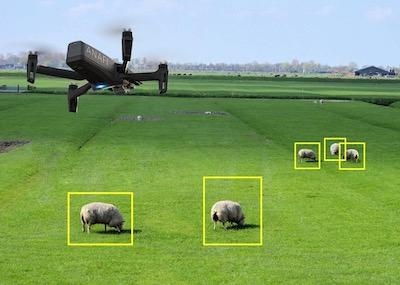
Parrot and RIIS’ whitepaper details one example of this technology in practice through an application called Cattle Counter. The app allows farmers and agriculture professionals to effortlessly and accurately quantify the size of cattle herds to automate the monitoring and counting process. Cattle Counter is currently available for download on the Google Play website.

“Our recent collaboration with Parrot perfectly illustrates the immense potential of developing apps for Parrot’s ANAFI drone platform,” said RIIS CEO and Founder Godfrey Nolan. “Leveraging the power of AI and machine learning apps with Parrot drones promises to provide previously impossible solutions to costly and time-consuming challenges.

Through its SDK Partner program, Parrot is working to create a global ecosystem of drone apps to serve the unique and ever-evolving needs of its enterprise and professional users. Through this program, Parrot is working with partners, like RIIS, to create and bring to market new applications, software and hardware that seamlessly integrates with Parrot ANAFI and ANAFI Thermal drones.

(Image provided with Parrot news release)

FMI: www.parrot.com

Advertisement

More News

Unfortunate... ANN/SportPlane Resource Guide Adds To Cautionary Advisories

The Industry Continues to be Rocked By Some Questionable Operations Recent investigations and a great deal of data has resulted in ANN’s SportPlane Resource Guide’s rep>[...]

ANN FAQ: Turn On Post Notifications

Make Sure You NEVER Miss A New Story From Aero-News Network Do you ever feel like you never see posts from a certain person or page on Facebook or Instagram? Here’s how you c>[...]

ANN's Daily Aero-Term (04.29.24): Visual Approach Slope Indicator (VASI)

Visual Approach Slope Indicator (VASI) An airport lighting facility providing vertical visual approach slope guidance to aircraft during approach to landing by radiating a directio>[...]

ANN's Daily Aero-Term (04.28.24): Airport Marking Aids

Airport Marking Aids Markings used on runway and taxiway surfaces to identify a specific runway, a runway threshold, a centerline, a hold line, etc. A runway should be marked in ac>[...]

ANN's Daily Aero-Linx (04.28.24)

Aero Linx: The Skyhawk Association The Skyhawk Association is a non-profit organization founded by former Skyhawk Pilots which is open to anyone with an affinity for the A-4 Skyhaw>[...]

blog comments powered by Disqus


Advertisement

Advertisement

Podcasts

Advertisement

© 2007 - 2024 Web Development & Design by Pauli Systems, LC