GE Aviation Offers 3D Airport Maps And High-Resolution Earth Imagery | Aero-News Network
Aero-News Network
RSS icon RSS feed
podcast icon MP3 podcast
Subscribe Aero-News e-mail Newsletter Subscribe

Airborne Unlimited -- Most Recent Daily Episodes

Episode Date

Airborne-Monday

Airborne-Tuesday

Airborne-Wednesday Airborne-Thursday

Airborne-Friday

Airborne On YouTube

Airborne-Unlimited-05.05.25

Airborne-NextGen-05.06.25

AirborneUnlimited-05.07.25

Airborne-Unlimited-05.01.25

AirborneUnlimited-05.02.25

Thu, Mar 08, 2012

GE Aviation Offers 3D Airport Maps And High-Resolution Earth Imagery

ICAO-Compliant Digital Terrain And Obstacle Data Now Available Worldwide

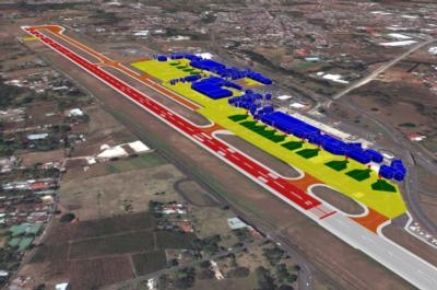
An agreement between GE Aviation and GeoEye will make ICAO-compliant terrain and obstacle aeronautical data derived from GeoEye’s high resolution Earth imagery available to the aviation industry. GE is showcasing this technology at ATC Global this week in Amsterdam.

As the first offering under this agreement, GE will provide ICAO Annex 15 Area-2 terrain and obstacle databases to support the development of new Performance-based Navigation (PBN) flight paths around the world. This digital, highly detailed terrain and obstacle mapping, collected by some of the world’s highest-resolution commercial earth-imaging satellites, will support the world's airport, airlines and aviation authorities as they move to adopt PBN.

“This advanced aeronautical data, along with our Required Navigation Performance (RNP) products, will accelerate the deployment of RNP flight paths that will help meet the global challenge of increasing efficiency in the world's air traffic management system,” said Giovanni Spitale, general manager of GE’s PBN Services. “It will allow the benefits of PBN to be achieved earlier for the global air transportation community - saving time, fuel, reducing emissions and noise while increasing hourly operations frequency and maintaining safety.”

Additional GE Aviation offerings under the agreement will support advanced terrain and obstacle visualization, surface guidance through airport mapping databases (AMDB), pilot simulator training and flight operations quality assurance (FOQA) replay. Avionics providers, airlines, and ANSPs will benefit from access to accurate and current real world views of critical topography, obstacles and airport details.

“Over the next decade, we will eventually provide this aeronautical data for hundreds of airports in the world,” continued Spitale. “This will become the reference geospatial database for the aviation community.” (Image provided by GE Avaition)

FMI: www.geoeye.com, www.ge.com/aviation

Advertisement

More News

ANN's Daily Aero-Term (05.07.25): Terminal Radar Service Area

Terminal Radar Service Area Airspace surrounding designated airports wherein ATC provides radar vectoring, sequencing, and separation on a full-time basis for all IFR and participa>[...]

ANN's Daily Aero-Linx (05.07.25)

Aero Linx: Utah Back Country Pilots Association (UBCP) Through the sharing experiences, the UBCP has built upon a foundation of safe operating practices in some of the most challen>[...]

Classic Aero-TV: Anousheh Ansari -- The Woman Behind The Prize

From 2010 (YouTube Edition): Imagine... Be The Change... Inspire FROM 2010: One of the more unusual phone calls I have ever received occurred a few years ago... from Anousheh Ansar>[...]

NTSB Prelim: Bell 206B

(Pilot) Felt A Shudder And Heard The Engine Sounding Differently, Followed By The Engine Chip Detector Light On April 14, 2025, about 1800 Pacific daylight time, a Bell 206B, N1667>[...]

Airborne-NextGen 05.06.25: AF Uncrewed Fighters, Drones v Planes, Joby Crew Test

Also: AMA Names Tyler Dobbs, More Falcon 9 Ops, Firefly Launch Unsuccessful, Autonomous F-16s The Air Force has begun ground testing a future uncrewed jet design in a milestone tow>[...]

blog comments powered by Disqus


Advertisement

Advertisement

Podcasts

Advertisement

© 2007 - 2025 Web Development & Design by Pauli Systems, LC