Wed, May 14, 2014
EASA Certifies The Dual Touchscreen Nav Devices
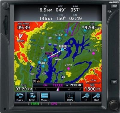
EASA has certified the installation of the dual touchscreen-controlled Garmin GTN 725 in the ATR 42 and ATR 72 aircraft, Garmin announced Monday, saying the GTN 725 GPS navigators expand the operating utility of the ATR 42/72, by offering Precision-Area Navigation (P-RNAV) capabilities to operators in Europe.
“Garmin continues a legacy of making investments to ensure that operators in Europe have solutions available that offer aircraft the capability to fly shorter routes with higher levels of accuracy,” said Carl Wolf, vice president of aviation sales and marketing. “The GTN 725 is a solution for operators in the ATR 42 and ATR 72 that enables them to fly P-RNAV procedures, which expands the operational capability of the aircraft throughout European airspace.”
When incorporating dual GTN 725s into the ATR 42/72, operators gain additional access to airports with higher levels of operating requirements. The dual GTN 725 installation offers pilots flying the ATR 42/72 the ability to fly shorter, more direct routes in airspaces utilizing P-RNAV procedures. Fewer radar vectors are needed thereby reducing the workload for both the pilot and air traffic control, which streamlines navigation through complex airspace. Similar to the functionality of B-RNAV, P-RNAV procedures feature the same capability with a higher level of accuracy.
Complete with a range of advanced flight display capabilities, the GTN 725 offers operators rich, interactive mapping that also displays airspace, frequency information and more. The touchscreen interface allows pilots to graphically edit flight plans on the moving map display, providing an easy and intuitive way to make flight plan modifications at any time.
The GTN 725 is compatible with optional Garmin ChartView powered by Jeppesen. Instrument Approach Procedures are conveniently overlaid on the moving map display, offering operators elevated situational awareness when transitioning from the enroute to approach phases of flight. Garmin SafeTaxi airport diagrams are conveniently geo-referenced on the GTN 725 so runways, taxiways, FBO’s and hangars are easily identifiable and navigating around unfamiliar airports is simplified.
(Image provided by Garmin)
More News
Area Navigation (RNAV) A method of navigation which permits aircraft operation on any desired flight path within the coverage of ground− or space−based navigation aids >[...]
Aero Linx: The Collings Foundation The Collings Foundation is a non-profit, Educational Foundation (501(c)3), founded in 1979. The purpose of the Foundation is to preserve and exhi>[...]
“We learned a great deal in the process, such as greater coding skills, soldering techniques, and video editing skills...” Source: Cuyahoga County Team Captain John Ana>[...]
Also: Swift Hits 56000', 100 Midnight Order, $1.4B For ATC, USCG/USAF Rescue Op INTEGRAL E, the all-electric version of Aura Aero’s two-seat aircraft, made its maiden flight >[...]
Also: Van Celebrates 85th, Trio Pro Pilot Autopilot, Joby on MSFS24, Sonex Transition The BushCat was manufactured in South Africa by SkyReach beginning in 2014, selling its first >[...]