Aviation Weather, Flight Planning And Airport Data On Your Cell Phone | Aero-News Network
Aero-News Network
RSS icon RSS feed
podcast icon MP3 podcast
Subscribe Aero-News e-mail Newsletter Subscribe

Airborne Unlimited -- Most Recent Daily Episodes

Episode Date

Airborne-Monday

Airborne-Tuesday

Airborne-Wednesday Airborne-Thursday

Airborne-Friday

Airborne On YouTube

Airborne-Unlimited-04.29.24

Airborne-Unlimited-04.23.24

Airborne-Unlimited-04.24.24 Airborne-FltTraining-04.25.24

Airborne-Unlimited-04.26.24

Tue, Apr 21, 2009

Aviation Weather, Flight Planning And Airport Data On Your Cell Phone

Pilot My-Cast Adds Canadian WX

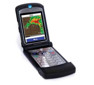
Digital Cyclone, Inc., a subsidiary of Garmin Ltd.), now offers AOPA Airport Directory data and Canadian radar, METARs and TAFs on Pilot My-Cast by Garmin, a cell phone based product that provides critical aviation weather data and flight planning services. This content is in addition to the U.S. weather and flight filing data already available on Pilot My-Cast.

Pilot My-Cast is compatible with many popular phone models, such as BlackBerry and Windows Mobile devices, and is available from all major wireless carriers in the U.S. including AT&T, Sprint, Verizon, Alltel, as well as Handmark and Handango. “Pilot My-Cast is an indispensable tool to those who fly regularly,” said Gary Kelley, Garmin’s vice president of marketing. “It makes it extremely easy to check the weather, make educated go or no-go decisions, and file a flight plan, all directly from your cell phone.”

AOPA’s Airport Directory is now available on Pilot My-Cast and includes information for over 5,300 public-use airports and more than 7,000 FBOs, such as pilot services, ground transportation, lodging, restaurants, and local attractions. Also new to Pilot My-Cast is Canadian weather information from the Environment Canada weather service that includes radar, METARs and TAFs. The Canadian weather is in addition to the National Weather Service (NWS) data that is available for any location in the U.S. such as NEXRAD, METARs, TAFs, SIGMETs, AIRMETs, PIREPs, visible and infrared satellite loops, lightning, winds aloft, area forecasts (FA), TFRs, and more. Weather information is displayed in either text or graphical format, and some information – METARs, winds aloft, PIREPs, AIRMETs, SIGMETs, TFRs – is presented in both text and graphical formats for easy interpretation.

Pilot My-Cast is unique because its data is transmitted directly from the foremost providers – NWS and Environment Canada, as well as aviation data from the Federal Aviation Administration. By offering data directly from prominent sources, pilots can be confident that the weather and flight planning information they receive is up-to-date and accurate. Pilot My-Cast was the first to offer the ability to file a flight plan using the phone’s keypad to type in the flight plan data. This easy-to-use flight filing feature stores the most recently filed flight plan, which means pilots only need to alter information that has changed from the last time they filed. When the pilot is ready to submit the plan, a few keystrokes will automatically send the information to the DUATs provider.

Customers can subscribe to Pilot My-Cast by Garmin for $9.95 per month.

FMI: www.garmin.com

Advertisement

More News

Unfortunate... ANN/SportPlane Resource Guide Adds To Cautionary Advisories

The Industry Continues to be Rocked By Some Questionable Operations Recent investigations and a great deal of data has resulted in ANN’s SportPlane Resource Guide’s rep>[...]

ANN FAQ: Turn On Post Notifications

Make Sure You NEVER Miss A New Story From Aero-News Network Do you ever feel like you never see posts from a certain person or page on Facebook or Instagram? Here’s how you c>[...]

ANN's Daily Aero-Term (04.29.24): Visual Approach Slope Indicator (VASI)

Visual Approach Slope Indicator (VASI) An airport lighting facility providing vertical visual approach slope guidance to aircraft during approach to landing by radiating a directio>[...]

ANN's Daily Aero-Term (04.28.24): Airport Marking Aids

Airport Marking Aids Markings used on runway and taxiway surfaces to identify a specific runway, a runway threshold, a centerline, a hold line, etc. A runway should be marked in ac>[...]

ANN's Daily Aero-Linx (04.28.24)

Aero Linx: The Skyhawk Association The Skyhawk Association is a non-profit organization founded by former Skyhawk Pilots which is open to anyone with an affinity for the A-4 Skyhaw>[...]

blog comments powered by Disqus


Advertisement

Advertisement

Podcasts

Advertisement

© 2007 - 2024 Web Development & Design by Pauli Systems, LC