Cassini Radar Sees Bright Flow-Like Feature on Titan | Aero-News Network
Aero-News Network
RSS icon RSS feed
podcast icon MP3 podcast
Subscribe Aero-News e-mail Newsletter Subscribe

Airborne Unlimited -- Most Recent Daily Episodes

Episode Date

Airborne-Monday

Airborne-Tuesday

Airborne-Wednesday Airborne-Thursday

Airborne-Friday

Airborne On YouTube

Airborne-Unlimited-11.10.25

AirborneNextGen-
11.11.25

Airborne-Unlimited-11.12.25

Airborne-Unlimited-11.06.25

AirborneUnlimited-11.07.25

LIVE MOSAIC Town Hall (Archived): www.airborne-live.net

Thu, Nov 11, 2004

Cassini Radar Sees Bright Flow-Like Feature on Titan

The Mysteries Of Titan's Surface Deepen

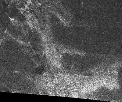
A strikingly bright feature that is consistent with an active geology has been seen in one of Cassini's first radar images of Saturn's moon Titan. There are many possibilities for what it is but one of the leading candidates is that it may be a 'cryovolcanic' flow or 'ice volcano'.

"It may be something that flowed," said Cassini radar team member Dr. Ralph Lorenz of the University of Arizona, Tucson. "Or it could be something carved by erosion. It's too early to say.

"But it looks very much like it's something that oozed across the surface. It may be some sort of cryovolcanic flow, an analog to volcanism on Earth that is not molten rock but, at Titan's very cold temperatures, molten ice."

Cassini's radar mapped about one percent of Titan's surface during the spacecraft's first close Titan flyby on Oct. 26. The radar survey covered a strip 120 kilometers (75 miles) wide and 1,960 kilometers (1,200 miles) long in Titan's northern hemisphere.

Cassini was flying about 2,494 (1,550 miles) above Titan's surface, with its radar centered at about 45 degrees north, 30 degrees west, when it mapped the 230-square-kilometer (90-square-mile) area shown in the new radar image. The Cassini radar team presented the image yesterday at the 36th annual meeting of the American Astronomical Society’s Division for Planetary Sciences in Louisville (KY).

The radar instrument on board Cassini works by bouncing radio signals off Titan's surface and timing their return. The more signal reflected back to the spacecraft, the brighter the imaged area. Turning radio signals into radar images is time consuming because so many numerical calculations must be made. "There's no such thing as a 'raw' radar image," said Lorenz.

Just two days after the Oct. 26 flyby, Cassini scientists knew that Titan is not a crater-pocked dead world, but a much more interesting place. Titan's surface is young. It might have been altered by ongoing dynamic geologic processes that cover and obscure old impact craters. Lorenz, and Cassini interdisciplinary scientist Dr. Jonathan Lunine also of the University of Arizona, and other Cassini scientists, agree in this interpretation.

Given this newest image, Lunine said, "Cassini's radar has provided the first evidence for possible young cryovolcanism on Titan's surface. Now our challenge is to find out what is flowing, how it works, and the implications for Titan's evolution."

FMI: http://saturn.jpl.nasa.gov, www.nasa.gov/cassini

Advertisement

More News

ANN FAQ: Contributing To Aero-TV

How To Get A Story On Aero-TV News/Feature Programming How do I submit a story idea or lead to Aero-TV? If you would like to submit a story idea or lead, please contact Jim Campbel>[...]

Classic Aero-TV: Bob Hoover At Airventure -- Flight Test and Military Service

From 2011 (YouTube Edition): Aviation's Greatest Living Legend Talks About His Life In Aviation (Part 5, Final) ANN is pleased to offer you yet another snippet from the public conv>[...]

Aero-News: Quote of the Day (11.12.25)

“All Air Traffic Controllers must get back to work, NOW!!! Anyone who doesn’t will be substantially ‘docked. For those Air Traffic Controllers who were GREAT PATR>[...]

ANN's Daily Aero-Linx (11.12.25)

Aero Linx: American Navion Society Welcome to the American Navion Society. Your society is here to support the Navion community. We are your source of technical and operating infor>[...]

ANN's Daily Aero-Term (11.12.25): Glideslope Intercept Altitude

Glideslope Intercept Altitude The published minimum altitude to intercept the glideslope in the intermediate segment of an instrument approach. Government charts use the lightning >[...]

blog comments powered by Disqus


Advertisement

Advertisement

Podcasts

Advertisement

© 2007 - 2025 Web Development & Design by Pauli Systems, LC