Sat, Sep 07, 2019
Meets Requirement For U.S. Navy Advanced Helicopter Training System Competition
Garmin's G1000H NXi integrated flight deck has received IFR certification. Bell recently achieved this certification in the 407GXi, which gives pilots the flexibility of operating in degraded weather conditions with valuable situational awareness tools and advanced capabilities in a next generation integrated flight deck. IFR certification meets the needs of single-engine helicopter owners and operators and is also a requirement for the U.S. Navy Advanced Helicopter Training System competition.
“In collaboration with Bell, we are excited to bring the first IFR certified Garmin integrated flight deck to the single-engine rotorcraft market,” said Carl Wolf, vice president of aviation sales and marketing. “The G1000H NXi gives helicopter owners and operators a modern glass flight deck that boasts an unprecedented level of performance, a superior feature set and a level of innovation and integration beyond what is found on a single-engine IFR certified helicopter today.”
The G1000H NXi offers a number of safety enhancing features and optional capabilities that are tailored to helicopter pilots. Pilot workload is significantly reduced with helicopter terrain awareness warning system (HTAWS), which offers vibrant five-color display shading and audible voice callout alerts for powerlines and potential terrain and obstacle hazards along the flight path. The addition of helicopter synthetic vision technology (HSVT) seamlessly blends topographic database information to display real-time 3D images. HSVT also alerts pilots of potential ground hazards by displaying terrain, obstacles and powerlines which pose a threat to the aircraft. Further reducing pilot workload, WireAware™ wire-strike avoidance technology graphically overlays the most comprehensive powerline information on the moving map page. WireAware coverage is available in the U.S. as well as some locations in Canada and Mexico.
Wireless connectivity between mobile devices and the G1000H NXi gives pilots added flexibility when interfacing with the integrated flight deck. Connext cockpit connectivity with added Database Concierge uploads and syncs aviation databases to the G1000H NXi with a compatible tablet or smartphone. G1000H NXi also supports wireless flight plan transfer from a compatible mobile device to the integrated flight deck. Additional connectivity features include the sharing of traffic, weather and GPS position information between compatible mobile devices and the integrated flight deck.
The G1000H NXi is capable of displaying helicopter route charts throughout eight U.S. metropolitan areas, including the Gulf of Mexico. Additional features and capabilities available with the G1000H NXi include: SiriusXM high-resolution animated weather radar imagery, Telligence voice control, global voice/text, Automatic Dependent Surveillance-Broadcast (ADS-B) Out and much more. The system is also capable of displaying onboard weather radar, radar altimeter, engine information and video input from compatible camera sources. To support night operations, the G1000H NXi is also compatible with night vision goggles (NVG).
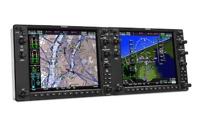
(Image provided with Garmin news release)
More News
He Attempted To Restart The Engine Three Times. On The Third Restart Attempt, He Noticed That Flames Were Coming Out From The Right Wing Near The Fuel Cap Analysis: The pilot repor>[...]
Make Sure You NEVER Miss A New Story From Aero-News Network Do you ever feel like you never see posts from a certain person or page on Facebook or Instagram? Here’s how you c>[...]
From 2009 (YouTube Edition): Leading Air Show Performers Give Their Best Advice for Newcomers On December 6th through December 9th, the Paris Las Vegas Hotel hosted over 1,500 air >[...]
Aero Linx: NASA ASRS ASRS captures confidential reports, analyzes the resulting aviation safety data, and disseminates vital information to the aviation community. The ASRS is an i>[...]
“For our inaugural Pylon Racing Seminar in Roswell, we were thrilled to certify 60 pilots across our six closed-course pylon race classes. Not only did this year’s PRS >[...]
 NTSB Final Report: Rutan Long-EZ