Here's The NUMBER ONE Selection From ANN's Top 10
Products/Programs Of 2008
Final Compilations by ANN Editor-In-Chief/Dog Walker, Jim
Campbell
When it comes to the people, planes and products of the aviation
business, ANN firmly believes there is no such thing as an
embarrassment of riches. 2008 saw a spate of new programs and
'gadgets' designed to separate a pilot from his flying dollar...
fortunately, the vast majority of them are quite worthy of
foregoing the occasional $500 hamburger or two
.

 In fact, for 2008 we
really had to struggle with the list in order to pare it down to a
manageable assembly and if we hadn't, we'd have easily had to
increase the size of our annual 'Best Of' list to several dozen, or
so, to accommodate them all.
In fact, for 2008 we
really had to struggle with the list in order to pare it down to a
manageable assembly and if we hadn't, we'd have easily had to
increase the size of our annual 'Best Of' list to several dozen, or
so, to accommodate them all.
From established products that continue to impress, to new and
exciting developments across the range of general aviation... here,
to our eyes, is the VERY BEST from our list of the 10 most worthy
'gadgets' and programs of 2008. Let's start 2009 off with a bang
with the announcement that Garmin's GPSMAP 696 RAN AWAY from the
competition and has earned its selection at the top of ANN's
Aero-Products Of The Year List for 2008.
Wonderbox: The Garmin 696
When we first heard about it and got to paw it with our sweaty
little hands for real, we could barely keep the secret… we
sat on this confidence for several weeks terrified that our
excitement might let the feline out of the paper sack as mighty
Garmin upped the ante in the ongoing portable GPS/Map wars with the
introduction of the GPSMAP 696.
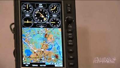
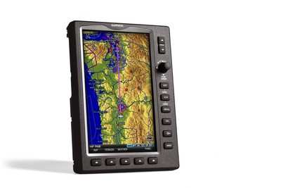
The GPSMAP 696 is an all new, tablet-style device with a large,
7-inch portrait screen that makes it possible to view an entire
approach plate on the display. The high-resolution, sunlight
readable screen uses Garmin's latest technology to ensure that
pilots will be able to read the vibrant display day or night. The
bezel that frames the bright screen has multiple keys on the bottom
and right sides. The soft keys at the bottom of the display control
the most commonly used features of the current page, such as
turning the weather display on/off. The dedicated keys on the
display's right side have specific functions such as nearest,
direct to, flight plan, zoom in/out and menu. Also on the display's
right side is a rotary knob/joystick, similar to the G1000's
joystick, that lets pilots enter airport identifiers, pan the map,
or scroll to page and sub-page groups.
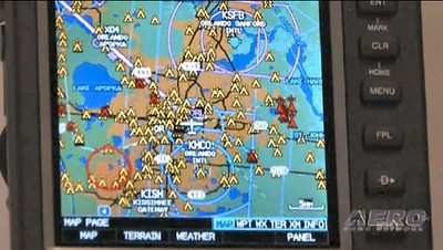
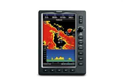
The GPSMAP 696's IFR map mode displays a map similar to a
standard enroute chart that has important features like victor
airways, jet routes, minimum enroute altitude (MEA) and leg
distance. The 696's IFR map mode also offers more situational
awareness than traditional charts because it subtlety displays
major visual reference points like rivers, state boundaries,
highways and railroad tracks from Garmin's built-in basemap.

The GPSMAP 696 also includes Garmin FliteCharts, an electronic
version of the National Aeronautical Chart Office (NACO) U.S.
Terminal Procedures Publication. With FliteCharts, pilots can
quickly find and view all NACO departure procedures (DP), standard
terminal arrival routes (STARs), approach charts and airport
diagrams. If the current approach is known, the GPSMAP 696
automatically selects the correct chart based on the flight plan.
FliteCharts are available every 28-days and will not be available
on the 696 if they are not updated regularly. The GPSMAP 696 may be
used in lieu of paper approach charts when used in accordance with
AC 90-78.
Garmin notes that other popular features found on the GPSMAP 696
include Smart Airspace, SafeTaxi and AOPA Airport Directory data.
During flight, Garmin's Smart Airspace automatically highlights
airspace close to the pilot's current altitude and de-emphasizes
airspace away from the current altitude, which ultimately aids in
situational awareness. With SafeTaxi, taxiing at unfamiliar
airports is also easier because the GPSMAP 696 includes
geo-referenced diagrams of over 850 U.S. airports that identify
runways, taxiways and hangars, as well as the aircraft's exact
location on the field.

The AOPA Airport Directory data is an electronic version of
AOPA's popular U.S. pilot guide that includes information for over
5,300 public-use airports and more than 7,000 FBOs, such as pilot
services, ground transportation, lodging, restaurants, and local
attractions. In addition, Garmin's electronic version of the AOPA
Airport Directory highlights airports where pilots can save on fuel
by using self-service fueling locations.
The GPSMAP 695 and 696 are available immediately for an expected
street price of $2,695 and $3,295, respectively. The GPSMAP 696
package includes a yoke mount, GXM 40 smart antenna,
cigarette-lighter adapter, AC adapter cable, USB-to-PC interface
cable, low-profile remote GPS antenna, unit cover, free Jeppesen
update certificate, owner's manual and quick-reference guide.
Those who have them (including some close associates of ours)
are amazed at this thing and the owner reports are nearly ecstatic
(nope, we're NOT exaggerating), pretty much giving them what they
wanted all long… a full-fledged MFD that they could tote
anywhere they wanted. It has NO peers… it totally blows away
pseudo-pretenders to the throne like the awkwardly aging
AnywhereMap (which may find future employment as a doorstop) and
while not exactly cheap, the bang for the buck is
considerable. Folks… from a company that keeps hitting
home-runs, the GPSMAP 696 is a Grand Slam.
HIGHLY Recommended.
See The GPSMAP 696 On Aero-TV!
 Aero-News: Quote of the Day (04.28.25)