MountainScope Surpasses 100,000 hours With ADS-B | Aero-News Network
Aero-News Network
RSS icon RSS feed
podcast icon MP3 podcast
Subscribe Aero-News e-mail Newsletter Subscribe

Airborne Unlimited -- Most Recent Daily Episodes

Episode Date

Airborne-Monday

Airborne-Tuesday

Airborne-Wednesday Airborne-Thursday

Airborne-Friday

Airborne On YouTube

Airborne-Unlimited-10.27.25

AirborneNextGen-
10.28.25

Airborne-Unlimited-10.29.25

Airborne-Unlimited-10.30.25

AirborneUnlimited-10.17.25

Fri, Nov 30, 2007

MountainScope Surpasses 100,000 hours With ADS-B

As noted in our Aero-TV coverage from Oshkosh 2007 (see video attached below), FAA administrator Marion Blakey mandated that ADS-B will be the industry standard for traffic awareness by 2020.

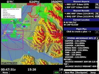
This may sound like it's a long ways off, but PCAvionics, publisher of MountainScope moving-map software, has been working with the FAA Capstone program since 2003 to develop display systems for ADS-B. Mountainscope has been ADS-B compatible for four years, overlaying traffic and weather on MountainScope's industry-leading terrain awareness maps.

Partnering with ADS-B Technologies (www.ads-b.com), PCAvionics has supplied over 120 ADS-B cockpit display tablets to flight schools in China. Since program inception, these schools have logged over 250,000 hours with ADS-B, 100,000 of which were logged using MountainScope displays. Several other countries are in the process of setting up similar systems. This makes MountainScope the proven leader in portable ADS-B cockpit displays worldwide.

PCAvionics tells ANN that it continues to advance its ADS-B mapping technology by working with ADS-B Technologies and the North Carolina DOT to refine and enhance the display. NCDOT started a program to install ADS-B ground stations that has since spread to cover the entire US east coast. That makes ADS-B a current, viable solution for traffic and weather in that part of the country.

The FAA has committed to completing a nationwide ADS-B infrastructure by 2010, with aircraft equipage required by 2020.

FMI: www.pcavionics.com; www.whyadsb.com

Advertisement

More News

ANN's Daily Aero-Term (10.31.25): Minimum Sector Altitude [ICAO]

Minimum Sector Altitude The lowest altitude which may be used under emergency conditions which will provide a minimum clearance of 300 m (1,000 feet) above all obstacles located in>[...]

ANN's Daily Aero-Linx (10.31.25)

Aero Linx: African Civil Aviation Commission (AFCAC) At AFCAC, our Safety Strategic Objective is to enhance Aviation Safety and the efficiency of Air Navigation Services in Africa.>[...]

NTSB Final Report: Airbus A321-271N (A1); Cessna 172N (A2)

The Local Controller’s Poor Judgment In Prioritization Of Their Ground Traffic Ahead Of Their Airborne Traffic Analysis: Hawaiian Airlines flight 70 (HAL70), N2165HA, an Airb>[...]

ANN FAQ: Follow Us On Instagram!

Get The Latest in Aviation News NOW on Instagram Are you on Instagram yet? It's been around for a few years, quietly picking up traction mostly thanks to everybody's new obsession >[...]

Airborne 10.30.25: Earhart Search, SpaceX Speed Limit, Welcome Back, Xyla!

Also: Beech M-346N, Metro Gains H160 EMS STC, New Bell Boss, Affordable Flying Expo Tickets NOW On Sale! Purdue University’s Research Foundation and the Archaeological Legacy>[...]

blog comments powered by Disqus


Advertisement

Advertisement

Podcasts

Advertisement

© 2007 - 2025 Web Development & Design by Pauli Systems, LC