Mon, Jul 26, 2010
Jeppesen Charts Available Soon For Portable GPS
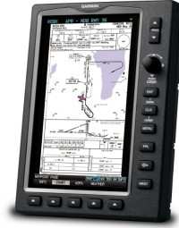
Garmin International's new and enhanced chart capabilities for
the GPSMAP 695/696 have been introduced Monday at AirVenture. This
top-of-the-line aviation portable will soon include georeferenced
Garmin FliteCharts, and cutomers also have the opportunity to
immediately subscribe to and receive Garmin’s georeferenced
ChartView powered by Jeppesen.
“We constantly solicit customer feedback in order to make
our products better, and these enhancements are a direct result of
customers’ requests for georeferenced charts,” said
Gary Kelley, Garmin’s vice president of marketing. “The
696 has a large, 7-inch portrait screen that is ideal for viewing
an entire approach plate. Now, pilots will be able to see their
aircraft’s exact position while monitoring other important
information on the approach
charts.”
Garmin FliteCharts is an electronic version of the National
Aeronautical Navigation Services Charts (AeroNav Services), which
was formerly NACO. FliteCharts lets pilots quickly find and view
all AeroNav Services Departure Procedures (DP), Standard Terminal
Arrival Routes (STARs), approach charts, and airport diagrams. If
the current approach is known, the GPSMAP 695/696 automatically
selects the correct chart based on the flight plan. Pilots will
have access to all approach plates currently published by AeroNav,
which encompasses over 15,000 charts and over 2,900 airports in the
U.S. FliteCharts updates are available from Garmin every 28 days,
and the new georeferenced capability will be included with the
regular updates.
ChartView brings an electronic version of Jeppesen’s
extensive, worldwide library of JeppView charts and airport
diagrams directly to the GPSMAP 695/696. ChartView displays
approach charts, arrival and departure procedures, and airport
diagrams.
Updates are available from Jeppesen every 14 days. The new
georeferenced version of Garmin FliteCharts will be available in
the fourth quarter 2010. FliteChart’s georeferenced support
is included in the standard FliteChart update. ChartView is
available immediately and will require a one-time additional $499
enabling key via fly.garmin.com, as well as the latest free device
software.
More News
A Puff Of Smoke Came Out From The Top Of The Engine Cowling Followed By A Total Loss Of Engine Power On May 9, 2025, about 1020 mountain daylight time, an experimental amateur-buil>[...]
From 2022 (YouTube Edition): Jenny, I’ve Got Your Number... Among the magnificent antique aircraft on display at EAA’s AirVenture 2022 was a 1918 Curtiss Jenny painstak>[...]
Very High Frequency (VHF) The frequency band between 30 and 300 MHz. Portions of this band, 108 to 118 MHz, are used for certain NAVAIDs; 118 to 136 MHz are used for civil air/grou>[...]
“From approximately November 2021 through January 2022, Britton-Harr, acting on behalf of AeroVanti, entered into lease-purchase agreements for five Piaggio-manufactured airc>[...]
Microburst A small downburst with outbursts of damaging winds extending 2.5 miles or less. In spite of its small horizontal scale, an intense microburst could induce wind speeds as>[...]
 NTSB Prelim: Lee Aviation LLC JA30 SuperStol