ForeFlight Releases Latest Update To Version 10 | Aero-News Network
Aero-News Network
RSS icon RSS feed
podcast icon MP3 podcast
Subscribe Aero-News e-mail Newsletter Subscribe

Airborne Unlimited -- Most Recent Daily Episodes

Episode Date

Airborne-Monday

Airborne-Tuesday

Airborne-Wednesday Airborne-Thursday

Airborne-Friday

Airborne On YouTube

Airborne-Unlimited-05.20.24

Airborne-Unlimited-05.28.24

Airborne-FlightTraining-05.29.24 Airborne-Unlimited-05.30.24

Airborne-Unlimited-05.24.24

Tue, May 08, 2018

ForeFlight Releases Latest Update To Version 10

Offers New Smart Airspace Features, Improved Search

The latest version of ForeFlight 10 builds upon a decade of innovation and delivers fantastic new smart airspace features, improved search capability to help you find what you need faster, automatic chart and data updates to keep your device ready to fly, and more, the company said in an email to the media.

ForeFlight’s improved app-wide Search functionality is smarter, faster, and more consistent across app views. Quickly find routes, cities, airports, aeronautical information, and procedures, as well as street addresses or intersections, place names (eg: “Central Park”), and scheduled flights.

ForeFlight 10 builds on the company's commitment to make flying easier through automation. You now have the option to automatically download chart and data updates when connected to Wi-Fi, according to the release.

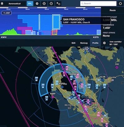
In addition to terrain and obstacles, Profile View now features an interactive vertical depiction of controlled, MOA, SUA, and TFR airspaces along your planned route. In the air, Profile View shows the aircraft’s altitude in relation to airspace along the flight track in real time. Airspace Highlight considers the flight’s climb, cruise, and descent trajectory and uses the Aeronautical Maps layer to automatically highlight airspace near the aircraft or along the route of flight. All other airspace dims to reduce visual clutter on the map.

ForeFlight now features Jeppesen’s global airspace information for FIRs, UIRs, controlled airspace, and special use airspace. Tap-hold anywhere on the Maps view to access center and radio frequencies, RVSM cruise tables, operational notes, speed restrictions, prior notification procedures, and communication details for CPDLC and satellite services.

As part of the ForeFlight Connect platform, ForeFlight provides an expanded version of the industry-standard GDL 90 Data Interface Specification for third-party devices to transmit live inflight weather, traffic, AHRS, device name information, and GPS data to ForeFlight Mobile.

(Image provided with ForeFlight media release)

FMI: www.foreflight.com

Advertisement

More News

ANN FAQ: Contributing To Aero-TV

How To Get A Story On Aero-TV News/Feature Programming How do I submit a story idea or lead to Aero-TV? If you would like to submit a story idea or lead, please contact Jim Campbel>[...]

ANN's Daily Aero-Linx (05.29.24)

Aero Linx: International Association of Professional Gyroplane Training (IAPGT) We are an Association of people who fly, build or regulate Gyroplanes, who have a dream of a single >[...]

ANN's Daily Aero-Term (05.29.24): NORDO (No Radio)

NORDO (No Radio) Aircraft that cannot or do not communicate by radio when radio communication is required are referred to as “NORDO.”>[...]

ANN's Daily Aero-Term (05.30.24): Beyond Visual Line Of Sight (BVLOS)

Beyond Visual Line Of Sight (BVLOS) The operation of a UAS beyond the visual capability of the flight crew members (i.e., remote pilot in command [RPIC], the person manipulating th>[...]

ANN's Daily Aero-Linx (05.30.24)

Aero Linx: Malibu M-Class Owners and Pilots Association (MMOPA) The Piper M-Class Owners & Pilots Association (PMOPA) is a not-for-profit organization dedicated to the interest>[...]

blog comments powered by Disqus


Advertisement

Advertisement

Podcasts

Advertisement

© 2007 - 2024 Web Development & Design by Pauli Systems, LC