ForeFlight Releases Latest Update To Version 10 | Aero-News Network
Aero-News Network
RSS icon RSS feed
podcast icon MP3 podcast
Subscribe Aero-News e-mail Newsletter Subscribe

Airborne Unlimited -- Most Recent Daily Episodes

Episode Date

Airborne-Monday

Airborne-Tuesday

Airborne-Wednesday Airborne-Thursday

Airborne-Friday

Airborne On YouTube

Airborne-Unlimited-10.20.25

AirborneNextGen-
10.21.25

Airborne-Unlimited-10.22.25

Airborne-FltTraining-10.23.25

AirborneUnlimited-10.17.25

Tue, May 08, 2018

ForeFlight Releases Latest Update To Version 10

Offers New Smart Airspace Features, Improved Search

The latest version of ForeFlight 10 builds upon a decade of innovation and delivers fantastic new smart airspace features, improved search capability to help you find what you need faster, automatic chart and data updates to keep your device ready to fly, and more, the company said in an email to the media.

ForeFlight’s improved app-wide Search functionality is smarter, faster, and more consistent across app views. Quickly find routes, cities, airports, aeronautical information, and procedures, as well as street addresses or intersections, place names (eg: “Central Park”), and scheduled flights.

ForeFlight 10 builds on the company's commitment to make flying easier through automation. You now have the option to automatically download chart and data updates when connected to Wi-Fi, according to the release.

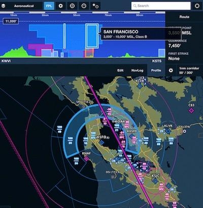
In addition to terrain and obstacles, Profile View now features an interactive vertical depiction of controlled, MOA, SUA, and TFR airspaces along your planned route. In the air, Profile View shows the aircraft’s altitude in relation to airspace along the flight track in real time. Airspace Highlight considers the flight’s climb, cruise, and descent trajectory and uses the Aeronautical Maps layer to automatically highlight airspace near the aircraft or along the route of flight. All other airspace dims to reduce visual clutter on the map.

ForeFlight now features Jeppesen’s global airspace information for FIRs, UIRs, controlled airspace, and special use airspace. Tap-hold anywhere on the Maps view to access center and radio frequencies, RVSM cruise tables, operational notes, speed restrictions, prior notification procedures, and communication details for CPDLC and satellite services.

As part of the ForeFlight Connect platform, ForeFlight provides an expanded version of the industry-standard GDL 90 Data Interface Specification for third-party devices to transmit live inflight weather, traffic, AHRS, device name information, and GPS data to ForeFlight Mobile.

(Image provided with ForeFlight media release)

FMI: www.foreflight.com

Advertisement

More News

Affordable Flying Expo Announces Industry MOSAIC Town Hall

Scheduled for Friday, November 7th at 1800ET, The MOSAIC Town Hall, Webcast At www.airborne-live.net One of the more intriguing features of the 2025 Affordable Flying Expo, schedul>[...]

Classic Aero-TV: Composite-FX Sets Elevates the Personal Helicopter Market

From 2023 (YouTube Edition): The Mosquito Evolves Formerly known as Mosquito, Trenton, Florida-based Composite FX is a designer and manufacturer of personal kit and factory-finishe>[...]

Aero-News: Quote of the Day (10.25.25)

“The Board is pleased to name Lisa as our next CEO after conducting a comprehensive succession planning process and believes this transition will ensure continued success for>[...]

ANN's Daily Aero-Term (10.25.25): Ground Stop (GS)

Ground Stop (GS) The GS is a process that requires aircraft that meet a specific criteria to remain on the ground. The criteria may be airport specific, airspace specific, or equip>[...]

NTSB Final Report: Gallow Daniel A Kitfox Classic IV

The Airplane Stalled Above The Runway Threshold, The Nose Dropped, The Nose Wheel Impacted The Runway, And The Airplane Flipped Over Analysis: The pilot reported that during the fi>[...]

blog comments powered by Disqus


Advertisement

Advertisement

Podcasts

Advertisement

© 2007 - 2025 Web Development & Design by Pauli Systems, LC