Aero-TV: Pro Line Fusion -- 'Touch What You Want to Change' | Aero-News Network
Aero-News Network
RSS icon RSS feed
podcast icon MP3 podcast
Subscribe Aero-News e-mail Newsletter Subscribe

Airborne Unlimited -- Most Recent Daily Episodes

Episode Date

Airborne-Monday

Airborne-Tuesday

Airborne-Wednesday Airborne-Thursday

Airborne-Friday

Airborne On YouTube

Airborne-Unlimited-09.08.25

AirborneNextGen-
09.09.25

Airborne-Unlimited-09.10.25

Airborne-AffordableFlyers-09.11.25

AirborneUnlimited-09.12.25

Fri, Oct 14, 2011

Aero-TV: Pro Line Fusion -- 'Touch What You Want to Change'

Touch-Screen Functionality Comes To Pro Line Avionics

When flying complex airplanes in instrument or other challenging conditions, anything that makes it easier for the flight crew to concentrate on flying the airplane is a good thing. Rockwell Collins was out of the gate early at Oshkosh this summer, introducing its touch-screen interface for the Pro Line Fusion Primary Flight Display.

"The theory is 'touch what you want to change'," says Rockwell Collins' Adam Evanschwartz. He says that the system is unique in the marketplace because of its HUD capability which allows pilots to increase their situational awareness while interacting with the PFD and MFD.

Evan Schwartz says that pilots find the system very intuitive after about a half hour of flying. In his demonstration, a touch in the center of the PFD brings up a menu which allows the system to be divided into two parts, showing primary instruments and synthetic vision on one side of the PFD, and a GPS terrain map on the other.

An icon-driven drag-and-drop interface allows pilots to change the display to show charts for primary, alternate, or enroute, and that display can also be divided into two equal parts for the display of even more granular data such as checklists.

The moving map function also allows the pilot to update route of flight by "rubber banding" the course line displayed for easy vectoring around weather, or a change in waypoints or primary and alternate airports. Weather radar and other information can also be overlayed on the moving maps.

FMI: www.rockwellcollins.com, www.youtube.com/aerotvnetwork, http://twitter.com/AeroNews


Advertisement

More News

ANN's Daily Aero-Term (09.11.25): Global Navigation Satellite System (GNSS)

Global Navigation Satellite System (GNSS) GNSS refers collectively to the worldwide positioning, navigation, and timing determination capability available from one or more satellit>[...]

ANN's Daily Aero-Linx (09.11.25)

Aero Linx: ShortWingPipers.Org "The mission of ShortWingPipers.Org is to provide an international on-line source of information and communication for owners and enthusiasts of Shor>[...]

Aero-News: Quote of the Day (09.11.25)

“This finding by Perseverance, launched under President Trump in his first term, is the closest we have ever come to discovering life on Mars. The identification of a potenti>[...]

Aero-FAQ: Dave Juwel's Aviation Marketing Stories -- ITBOA BNITBOB

Dave Juwel's Aviation Marketing Stories ITBOA BNITBOB ... what does that mean? It's not gibberish, it's a lengthy acronym for "In The Business Of Aviation ... But Not In The Busine>[...]

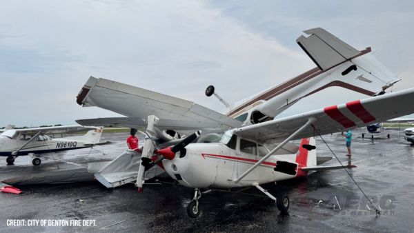
Airborne 09.10.25: 1000 Hr B29 Pilot, Airplane Pile-Up, Haitian Restrictions

Also: Commercial A/C Certification, GMR Adds More Bell 429s, Helo Denial, John “Lucky” Luckadoo Flies West CAF’s Col. Mark Novak has accumulated more than 1,000 f>[...]

blog comments powered by Disqus


Advertisement

Advertisement

Podcasts

Advertisement

© 2007 - 2025 Web Development & Design by Pauli Systems, LC