WY TFR: 06.03.07 | Aero-News Network
Aero-News Network
RSS icon RSS feed
podcast icon MP3 podcast
Subscribe Aero-News e-mail Newsletter Subscribe

Airborne Unlimited -- Most Recent Daily Episodes

Episode Date

Airborne-Monday

Airborne-Tuesday

Airborne-Wednesday Airborne-Thursday

Airborne-Friday

Airborne On YouTube

Airborne-Unlimited-04.21.25

Airborne-NextGen-04.22.25

AirborneUnlimited-04.23.25

Airborne-FltTraining-04.24.25

AirborneUnlimited-04.25.25

Fri, Jun 01, 2007

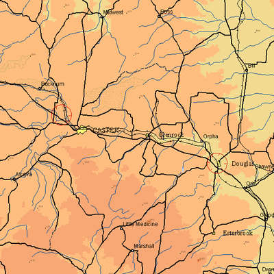
WY TFR: 06.03.07

NOTAM Number: FDC 7/2874
Issue Date: May 31, 2007 at 1927 UTC
Location: Casper, Wyoming
Beginning Date and Time: June 03, 2007 at 1530 UTC
Ending Date and Time: June 03, 2007 at 2035 UTC
Reason for NOTAM: Temporary flight restrictions for VIP (Very Important Person) Movement
Type: VIP
Replaced NOTAM(s): N/A

Affected Area(s)

Area A
Airspace Definition:
 Center: 13.7 nautical miles from MUDDY MOUNTAIN VORTAC(DDY) on the 205 radial (Latitude: 42º54'29"N, Longitude: 106º27'51"W)
 Radius: 3 nautical miles
 Altitude: From the surface up to but not including 3000 feet AGL
Effective Date(s):
 From June 03, 2007 at 1530 UTC (June 03, 2007 at 0930 MDT)
 To June 03, 2007 at 1620 UTC (June 03, 2007 at 1020 MDT)

Area B
Airspace Definition:
 Center: 8.8 nautical miles from HIPSHER VOR/DME(IIP) on the 293 radial (Latitude: 42º45'34"N, Longitude: 105º23'27"W)
 Radius: 3 nautical miles
 Altitude: From the surface up to but not including 3000 feet AGL
Effective Date(s):
 From June 03, 2007 at 1635 UTC (June 03, 2007 at 1035 MDT)
 To June 03, 2007 at 1910 UTC (June 03, 2007 at 1310 MDT)

Area C
Airspace Definition:
 Center: 13.7 nautical miles from MUDDY MOUNTAIN VORTAC(DDY) on the 205 radial (Latitude: 42º54'29"N, Longitude: 106º27'51"W)
 Radius: 3 nautical miles
 Altitude: From the surface up to but not including 3000 feet AGL
Effective Date(s):
 From June 03, 2007 at 1945 UTC (June 03, 2007 at 1345 MDT)
 To June 03, 2007 at 2035 UTC (June 03, 2007 at 1435 MDT)

Operating Restrictions and Requirements

No pilots may operate an aircraft in the areas covered by this NOTAM (except as described).

Unless otherwise authorized by ATC.

Other Information:

ARTCC: ZDV - Denver Center
Authority: Title 14 CFR section 91.141

FMI: www.tfr.faa.gov, Depicted TFR data may not be a complete listing. Pilots should not use the information on this website for flight planning purposes. For the latest information, call your local Flight Service Station at 1-800-WX-BRIEF.

Advertisement

More News

Aero-News: Quote of the Day (04.28.25)

“While legendary World War II aircraft such as the Corsair and P-51 Mustang still were widely flown at the start of the Korean War in 1950, a new age of jets rapidly came to >[...]

ANN's Daily Aero-Term (04.28.25): Decision Altitude (DA)

Decision Altitude (DA) A specified altitude (mean sea level (MSL)) on an instrument approach procedure (ILS, GLS, vertically guided RNAV) at which the pilot must decide whether to >[...]

ANN's Daily Aero-Linx (04.28.25)

Aero Linx: National Aviation Safety Foundation (NASF) The National Aviation Safety Foundation is a support group whose objective is to enhance aviation safety through educational p>[...]

Airborne-Flight Training 04.24.25: GA Refocused, Seminole/Epic, WestJet v TFWP

Also: Cal Poly Aviation Club, $$un Country, Arkansas Aviation Academy, Teamsters Local 2118 In response to two recent general aviation accidents that made national headlines, more >[...]

Aero-News: Quote of the Day (04.29.25)

“The FAA is tasked with ensuring our skies are safe, and they do a great job at it, but there is something about the system that is holding up the medical process. Obviously,>[...]

blog comments powered by Disqus


Advertisement

Advertisement

Podcasts

Advertisement

© 2007 - 2025 Web Development & Design by Pauli Systems, LC