Sun, Apr 01, 2012
Avidyne, Honeywell, Aspen Developing Game-Changing Software
ANN April 1st Special Edition
A consortium of avionics companies plan to announce at AEA next week that the next generation of synthetic vision terrain avoidance will be presented in 3D. Avidyne, Aspen, and Honeywell are collaborating on what they way will be game-changing technology.
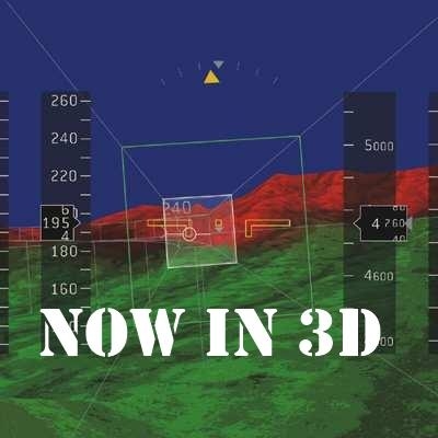
The new system will allow pilots to see the terrain in front of and surrounding them as if it were streaming out of the instrument panel. "Think of what that will do for safety," said Aspen CEO John Uczekaj. "It will be almost like you were actually looking outside the airplane, but will be color-coded like existing synthvis. So if there's a chance you'll hit that mountain or building, you'll see it represented in red."
Focus groups for the three companies have said that the only drawback is the special red and green glasses that are required to make the system work. "Pilots like their sunglasses," said Dan Schwinn, president and CEO of Avidyne. "So we're working with some vendors to make the 3D glasses as close to the classic aviator shades as we can."
Garmin, meanwhile, has decided to strike out on its own, bypassing the 3D step entirely for 'look-and-blink' technology it calls "4D". "It's not really 4D, because we couldn't figure out a practical way to incorporate the time element," said a Garmin insider not authorized to speak to the media. "But what we are able to do is project a 3D overlay on the aircraft windscreen that brings everything right into the cockpit. Then, to change your flight plan, just look at a spot on the windscreen and blink your eyes. You'll be prompted to confirm that it wasn't a random blink with another blink. That automatically adds a waypoint to your flightplan. Weather is incorporated as well, so you can just look-and-blink your way around heavy weather. If you look at a navaid or airport, you can double blink and open a menu that allows you to select airport information, frequencies, restricted airspace, and more. Just reach up and touch the point in space where you think the menu choice is, and it will appear in
space, allowing the pilot to never stop his scan for traffic."
Neither group gave any timeline for certification of the new technology. "Honestly, that's secondary. We were really looking for an excuse to get out news releases for AEA," said a Honeywell spokesman who requested anonymity. "We can't let our names slip out of the media for too long."
More News
“While legendary World War II aircraft such as the Corsair and P-51 Mustang still were widely flown at the start of the Korean War in 1950, a new age of jets rapidly came to >[...]
Decision Altitude (DA) A specified altitude (mean sea level (MSL)) on an instrument approach procedure (ILS, GLS, vertically guided RNAV) at which the pilot must decide whether to >[...]
Aero Linx: National Aviation Safety Foundation (NASF) The National Aviation Safety Foundation is a support group whose objective is to enhance aviation safety through educational p>[...]
Also: Cal Poly Aviation Club, $$un Country, Arkansas Aviation Academy, Teamsters Local 2118 In response to two recent general aviation accidents that made national headlines, more >[...]
“The FAA is tasked with ensuring our skies are safe, and they do a great job at it, but there is something about the system that is holding up the medical process. Obviously,>[...]
 Aero-News: Quote of the Day (04.28.25)