Drone Suspected In Wildfire In Arizona | Aero-News Network
Aero-News Network
RSS icon RSS feed
podcast icon MP3 podcast
Subscribe Aero-News e-mail Newsletter Subscribe

Airborne Unlimited -- Most Recent Daily Episodes

Episode Date

Airborne-Monday

Airborne-Tuesday

Airborne-Wednesday Airborne-Thursday

Airborne-Friday

Airborne On YouTube

Airborne-Unlimited-07.07.25

Airborne-NextGen-07.08.25

AirborneUnlimited-07.09.25

Airborne-FlightTraining-07.10.25

AirborneUnlimited-07.11.25

Mon, Mar 12, 2018

Drone Suspected In Wildfire In Arizona

About 30 Firefighters Contained The Blaze That Burned 335 Acres

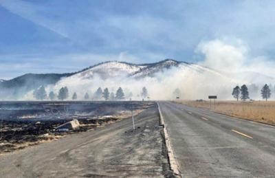
A drone is considered the culprit in a wildfire that burned some 335 acres near Kendrick Park in the Coconino National Forest near Flagstaff, AZ.

The U.S. Forest Service said in a news release that at approximately 12:35 p.m. local time last Tuesday, several firefighter crews responded to a smoke report from a drone in an area north of Flagstaff. The response included several Forest Service engines, patrols, and a water tender truck dispatched from the Summit fire department.

Overall, the fire burned 335-acres of forest land before the forward progress was stopped that afternoon.

Approximately 30 firefighters worked in the grasslands to stop the progress of this wildfire. The Chapel of the Holy Dove was in the area of the wildfire, but firefighting crews were able to protect the building by using fire to burn the fuels between the spreading wildfire and the Chapel. The backburning successfully kept damaging heat and flames away from the Chapel.

Several Forest Service engines, patrols and a water tender truck from Summit Fire responded to a smoke report from a drone on fire north of Flagstaff at approximately 12:35. The fire began near Forest Road 514 & FR 524 intersection by a drone which caught fire upon landing. The fire was reported as 50-acres in size upon the firefighter’s arrival.

Coconino National Forest spokesman George Jozens said authorities are still attempting to identify the type of drone, and who was operating the aircraft at the time on the incident.

(U.S. Forest Service image)

FMI: www.fs.usda.gov

Advertisement

More News

ANN's Daily Aero-Term (07.10.25): Performance-Based Navigation (PBN) [ICAO]

Performance-Based Navigation (PBN) [ICAO] Area navigation based on performance requirements for aircraft operating along an ATS route, on an instrument approach procedure or in a d>[...]

NTSB Prelim: Cessna 172

The Airplane Came To Rest Underneath A Set Of Damaged Power Distribution Lines On The Floor Of A Coulee On June 19, 2025, at 1412 mountain daylight time, a Cessna 172K airplane, N7>[...]

ANN's Daily Aero-Linx (07.10.25)

Aero Linx: FAA Managers Association (FAAMA) Recognized by the FAA, FAAMA is a professional association dedicated to the promotion of excellence in public service. The Association i>[...]

Classic Aero-TV: The Big Business of Diminutive Powerplants

From 2023 (YouTube Edition): Jet Central Micro-Turbine Engines Impress Founded in the late-1990s, Mexico City-based Jet Central produces a unique and fascinating line of micro-turb>[...]

Airborne 07.11.25: New FAA Bos, New NASA Boss (Kinda), WB57s Over TX

Also: ANOTHER Illegal Drone, KidVenture Educational Activities, Record Launches, TSA v Shoes The Senate confirmed Bryan Bedford to become the next Administrator of the FAA, in a ne>[...]

blog comments powered by Disqus


Advertisement

Advertisement

Podcasts

Advertisement

© 2007 - 2025 Web Development & Design by Pauli Systems, LC