Drone Suspected In Wildfire In Arizona | Aero-News Network
Aero-News Network
RSS icon RSS feed
podcast icon MP3 podcast
Subscribe Aero-News e-mail Newsletter Subscribe

Airborne Unlimited -- Most Recent Daily Episodes

Episode Date

Airborne-Monday

Airborne-Tuesday

Airborne-Wednesday Airborne-Thursday

Airborne-Friday

Airborne On YouTube

Airborne-Unlimited-05.19.25

Airborne-NextGen-05.20.25

AirborneUnlimited-05.21.25

Airborne-AffordableFlyers-05.22.25

AirborneUnlimited-05.23.25

Mon, Mar 12, 2018

Drone Suspected In Wildfire In Arizona

About 30 Firefighters Contained The Blaze That Burned 335 Acres

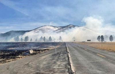
A drone is considered the culprit in a wildfire that burned some 335 acres near Kendrick Park in the Coconino National Forest near Flagstaff, AZ.

The U.S. Forest Service said in a news release that at approximately 12:35 p.m. local time last Tuesday, several firefighter crews responded to a smoke report from a drone in an area north of Flagstaff. The response included several Forest Service engines, patrols, and a water tender truck dispatched from the Summit fire department.

Overall, the fire burned 335-acres of forest land before the forward progress was stopped that afternoon.

Approximately 30 firefighters worked in the grasslands to stop the progress of this wildfire. The Chapel of the Holy Dove was in the area of the wildfire, but firefighting crews were able to protect the building by using fire to burn the fuels between the spreading wildfire and the Chapel. The backburning successfully kept damaging heat and flames away from the Chapel.

Several Forest Service engines, patrols and a water tender truck from Summit Fire responded to a smoke report from a drone on fire north of Flagstaff at approximately 12:35. The fire began near Forest Road 514 & FR 524 intersection by a drone which caught fire upon landing. The fire was reported as 50-acres in size upon the firefighter’s arrival.

Coconino National Forest spokesman George Jozens said authorities are still attempting to identify the type of drone, and who was operating the aircraft at the time on the incident.

(U.S. Forest Service image)

FMI: www.fs.usda.gov

Advertisement

More News

NTSB Prelim: Lee Aviation LLC JA30 SuperStol

A Puff Of Smoke Came Out From The Top Of The Engine Cowling Followed By A Total Loss Of Engine Power On May 9, 2025, about 1020 mountain daylight time, an experimental amateur-buil>[...]

Classic Aero-TV: Curtiss Jenny Build Wows AirVenture Crowds

From 2022 (YouTube Edition): Jenny, I’ve Got Your Number... Among the magnificent antique aircraft on display at EAA’s AirVenture 2022 was a 1918 Curtiss Jenny painstak>[...]

ANN's Daily Aero-Term (05.30.25): Very High Frequency (VHF)

Very High Frequency (VHF) The frequency band between 30 and 300 MHz. Portions of this band, 108 to 118 MHz, are used for certain NAVAIDs; 118 to 136 MHz are used for civil air/grou>[...]

Aero-News: Quote of the Day (05.30.25)

“From approximately November 2021 through January 2022, Britton-Harr, acting on behalf of AeroVanti, entered into lease-purchase agreements for five Piaggio-manufactured airc>[...]

ANN's Daily Aero-Term (05.31.25): Microburst

Microburst A small downburst with outbursts of damaging winds extending 2.5 miles or less. In spite of its small horizontal scale, an intense microburst could induce wind speeds as>[...]

blog comments powered by Disqus


Advertisement

Advertisement

Podcasts

Advertisement

© 2007 - 2025 Web Development & Design by Pauli Systems, LC