Jeppesen Releases EFB For The Commercial Aviation Industry
Jeppesen said Wednesday it is now offering the only electronic
flight bag (EFB) digital enroute charting application that replaces
paper charts in the cockpit for the commercial aviation industry.
The transformative digital enroute charting application from
Jeppesen features the only data-driven navigation information
presentation available in the industry and was recently determined
by the FAA to be suitable as an in-flight paper chart replacement.
The digital enroute application from Jeppesen is designed to
enhance air safety and reduce pilot workload to streamline
operational efficiency.
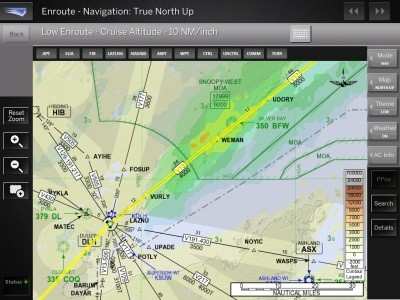
While typical digital enroute solutions only present a
“stitched together” graphical display of scanned
charts, the digital enroute application from Jeppesen features an
automated, interactive presentation of enroute chart information.
This display includes a true visual representation of enroute data
during flight with worldwide, real-time graphical and textual
weather overlay services. The dynamically rendered, digital
enroute application is an element of Jeppesen’s
industry-leading FliteDeck Pro electronic flight bag solution and
includes a complete library of terminal charts for origin and
destination airports.
“As the only true data-driven, paper replacement enroute
charting application available for the commercial aviation
industry, we have greatly enhanced EFB data services offered
through our innovative Jeppesen FliteDeck Pro solution and have
eliminated the need for cumbersome paper enroute charts in the
flight deck,” said Tim Huegel, director, Jeppesen Aviation
Portfolio Management. “FliteDeck Pro is an EFB solution built
by pilots, and replacing enroute paper charts in the flight deck is
an innovation that has been long-awaited by pilots to dramatically
improve situational awareness and meets a critical need of our
commercial aviation customers.”
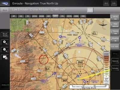
The Jeppesen enroute solution additionally provides operators
with real-time route planning capabilities and GPS-based positional
awareness in flight. Enhanced full-color, high-quality,
vector-based data with chart search and zoom features allow greater
detail to be rendered with a click directly on the EFB display. The
ability to enter operational notes and share information between
crew members are additional features of the new digital enroute
charting application. Pilots are also able to choose what flight
data is displayed, including airports, airways, waypoints, navaids,
airspace and terrain information, allowing for an individualized,
dynamically rendered on-screen presentation. The ability to display
high or low altitude IFR charts also is now available with the
Jeppesen enroute EFB solution.
Demand for an integrated data-driven, paper-replacement EFB
enroute charting application with global, real-time weather service
was identified during the FliteDeck Pro research and design
process, featuring coordination with professional pilots and
aviation industry leaders.

Targeted for commercial aircraft operators, the Jeppesen
FliteDeck Pro EFB enroute application supports XM satellite and
Internet connections available through the open design and simple
data integration framework of FliteDeck Pro. The digital enroute
solution now offers more value for airline investment committed to
in-flight cabin connectivity related to EFB capabilities. A mobile
version of the Jeppesen enroute solution is planned for
introduction in the near future.
Global weather data offered by the enroute solution for
FliteDeck Pro includes display of turbulence, lighting strike,
winds aloft and icing data, in addition to NEXRAD high resolution
next generation Doppler weather reports. North American customers
are also able to receive XM WX/WxWorx Satellite Weather data
through the new enroute solution that includes METAR/TAF current
condition reports and terminal aerodrome forecasts, graphical
temporary flight restrictions (TFR) and NEXRAD radar
reports.
 ANN's Daily Aero-Linx (12.12.25)

