Modernized GPS Block IIR Sat Ready For Launch | Aero-News Network
Aero-News Network
RSS icon RSS feed
podcast icon MP3 podcast
Subscribe Aero-News e-mail Newsletter Subscribe

Airborne Unlimited -- Most Recent Daily Episodes

Episode Date

Airborne-Monday

Airborne-Tuesday

Airborne-Wednesday Airborne-Thursday

Airborne-Friday

Airborne On YouTube

Airborne-Unlimited-06.23.25

Airborne-NextGen-06.24.25

AirborneUnlimited-06.25.25

Airborne-AffordableFlyers-06.26.25

AirborneUnlimited-06.27.25

Tue, Oct 16, 2007

Modernized GPS Block IIR Sat Ready For Launch

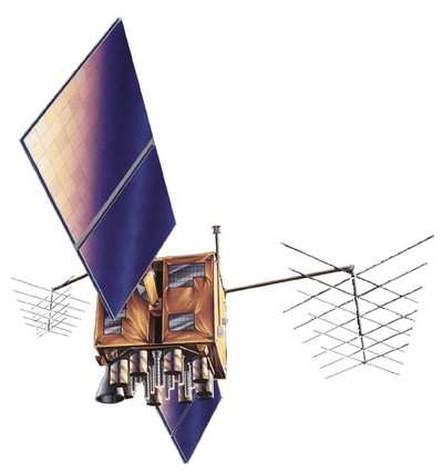
The fourth modernized Global Positioning System (GPS) Block IIR satellite built by Lockheed Martin for the U.S. Air Force is set for launch aboard a Delta II rocket on Oct. 17, from Cape Canaveral Air Force Station, Fla.

The GPS constellation provides critical situational awareness and precision weapon guidance for the military. The worldwide system also supports a wide range of civil, scientific and commercial functions - from air traffic control to the Internet - with precision location and timing information.

"We take great pride in our partnership with the Air Force on this vitally important system," said Don DeGryse, Lockheed Martin's vice president of Navigation Systems, and we look forward to extending our excellent record of delivering advanced navigation capabilities that better serve our warfighters and civil users around the globe."

Lockheed Martin Navigation Systems, Valley Forge, Pa. prime contractor for the GPS IIR program and navigation payload provider ITT of Clifton, N.J. designed and built 21 IIR spacecraft for the Global Positioning Systems Wing, Space and Missile Systems Center, Los Angeles Air Force Base, Calif.

The final eight spacecraft, designated Block IIR-M, were modernized to enhance operations and navigation signal performance for military and civilian GPS users around the globe. Lockheed Martin is also responsible for launch and flight operations support of the GPS IIR and IIR-M satellites.

The Global Positioning System enables properly equipped users to determine precise time and velocity and worldwide latitude, longitude and altitude to within a few meters. Air Force Space Command's 2nd Space Operations Squadron (2SOPS), based at Schriever Air Force Base, Colo., manages and operates the GPS constellation for both civil and military users.

FMI: www.lockheedmartin.com/GPS

Advertisement

More News

ANN's Daily Aero-Term (06.30.25): Ground Stop (GS)

Ground Stop (GS) The GS is a process that requires aircraft that meet a specific criteria to remain on the ground. The criteria may be airport specific, airspace specific, or equip>[...]

ANN's Daily Aero-Linx (06.30.25)

Aero Linx: Australian Transport Safety Bureau (ATSB) The Australian Transport Safety Bureau (ATSB) improves safety and public confidence in aviation, marine and rail transport thro>[...]

Aero-News: Quote of the Day (06.30.25)

“The Palo Alto stopover confirmed—yet again—that flight schools and aero-clubs are no longer just curious about electric training; they are ready to buy. In just >[...]

NTSB Final Report: ICON A5

Pilot’s Failure To Maintain Clearance From The Water While Flying At A Low Altitude Analysis: The flight of two airplanes was in cruise flight on a north heading about 50 ft >[...]

Airborne Affordable Flyers 06.26.25: PA18 Upgrades, ‘Delta Force’, Rhinebeck

Also: 48th Annual Air Race Classic, Hot Air Balloon Fire, FAA v Banning 100LL, Complete Remote Pilot The news Piper PA-18 Super Cub owners have been waiting for has finally arrived>[...]

blog comments powered by Disqus


Advertisement

Advertisement

Podcasts

Advertisement

© 2007 - 2025 Web Development & Design by Pauli Systems, LC