GXP Xplorer Effective In Very Disparate Missions
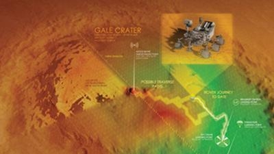
Deep in sub-Saharan Africa, migrating Savanna elephants are automatically detected and counted by visual profiling technology via satellite imagery to determine the effects of illegal poaching and agricultural development on their population. Meanwhile, more than 34 million miles away, the unmanned Mars Curiosity rover is adeptly navigating Martian terrain as it approaches the optimal point within Gale Crater to transmit geological data back to Earth.
Both of these missions use our Geospatial eXploitation Products (GXP) to ensure success. Specifically, GXP Xplorer – a web-based data management application – allows access, management and sharing capabilities for geospatial content while SOCET GXP can use satellite imagery to monitor herd-size trends in Africa or identify obstacles and optimal rover landing sites on the red planet.
GXP Xplorer crawls an organization’s entire federated network, identifying relevant files and creating a convenient in-place online catalog for geospatial data discovery while visualizing content in a convenient map view. This frees up analysts’ time to examine the data, as they can easily spend up to half of their time attempting to locate data across different systems, networks and geographical locations. Once discovered through GXP Xplorer, imagery of interest – typically from aerial sources – can be opened in SOCET GXP, which is used to identify, analyze and extract ground features, allowing for the development of enhanced geospatial intelligence.
“After using GXP exploitation software at Arizona State University to create ortho-mosaics of craters and inactive volcanoes on the moon, it’s really exciting to get to work on the development of these tools and witness firsthand the evolution of SOCET GXP capabilities,” said Megan Henriksen, an Engineering intern on sabbatical from the Lunar Reconnaissance team at Arizona State University. “Because I’ve always had such a strong interest in photogrammetry, it’s rewarding to be at the forefront of the conversation on how to solve our world’s geospatial challenges.”
Simple measurements such as distance between points, elevation and line of sight, as well as more-complex analysis, including terrain extraction, LiDAR visualization and multi-spectral analysis, are all enabled by SOCET GXP. This broad spectrum of capabilities enables image analysts to rapidly develop accurate and effective geospatial analysis while eliminating the need for multiple software packages.
Further differentiating GXP from its competition, these solutions are being enhanced with a variety of multi-source movement intelligence (MOVINT) capabilities, providing a solution to the manually intensive process of video surveillance. Built upon the Tracking Analytics Software Suite (TASS) – a recent addition through the acquisition of the Signal Innovations Group – these solutions enable automated processing and editing of video and motion imagery while delivering real-time intelligence on the movement of vehicles and people.
“Unlike other tracking tools, TASS can ingest multiple sources of movement intelligence, including full motion video, wide-area motion imagery, GMTI radar and many others,” said Colin Kubera, GXP product manager. “This provides more streamlined queries and workflows, allowing for significant time savings and greater persistence in detecting changes over time.”
The simultaneous tracking and indexing of all movement in a region enables analysts and cloud-based analytics to discover anomalies, key patterns and emerging threats often concealed in normal patterns of life. Supporting a variety of missions from counter-terrorism and force protection, to smuggling interdiction and border security, GXP’s evolving MOVINT and video exploitation capabilities ensure the effectiveness of Intelligence, Surveillance and Reconnaissance (ISR) operations.
GXP solutions extend into the field with mobile applications supporting remote image discovery, rapid communication of field data and tactical collaboration between enterprise and field personnel. Through customizable Common Response Graphics (CRG), which overlay Cartesian coordinates on top of a tactical map, GXP OnScene delivers a common operating picture for emergency response personnel, including law enforcement and fire response, while tracking the location of all field operatives via their mobile phone GPS.
At the 2016 Vice Presidential debate in Virginia, GXP OnScene was used to support security for participants, facilities personnel and attendees.
“Using the GXP OnScene technology, we were able to map out perimeters, define helicopter landing zones and develop CRGs for each of the buildings in order to better prepare for a potential situation,” said Scott Deitrich, GXP sales manager. “In addition, we were able to track security personnel in real-time on the big screen at Mission Command. The unique combination of blue force tracking along with a common operating picture for crisis response provides an industry solution that has been missing until now.”
(Image provided with BAE Systems news release)
 ANN's Daily Aero-Term (05.07.25): Terminal Radar Service Area

