ANN's Daily Aero-Tips (12.13.06): Satellite Images | Aero-News Network
Aero-News Network
RSS icon RSS feed
podcast icon MP3 podcast
Subscribe Aero-News e-mail Newsletter Subscribe

Airborne Unlimited -- Most Recent Daily Episodes

Episode Date

Airborne-Monday

Airborne-Tuesday

Airborne-Wednesday Airborne-Thursday

Airborne-Friday

Airborne On YouTube

Airborne-Unlimited-06.17.24

Airborne-NextGen-06.18.24

Airborne-Unlimited-06.12.24 Airborne-FltTraining-06.13.24

Airborne-Unlimited-06.14.24

Wed, Dec 13, 2006

ANN's Daily Aero-Tips (12.13.06): Satellite Images

Aero-Tips!

A good pilot is always learning -- how many times have you heard this old standard throughout your flying career? There is no truer statement in all of flying (well, with the possible exception of "there are no old, bold pilots.")

Aero-News has called upon the expertise of Thomas P. Turner, master CFI and all-around-good-guy, to bring our readers -- and us -- daily tips to improve our skills as aviators.

Some of them, you may have heard before... but for each of us, there will also be something we might never have considered before, or something that didn't "stick" the way it should have the first time we memorized it for the practical test.

Look for our daily Aero-Tips segments, coming each day to you through the Aero-News Network.

Aero-Tips 12.13.06

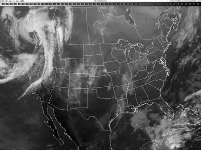
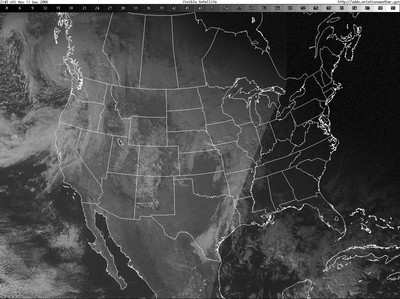
Take a look at the two satellite images below:


What's the difference between the two simultaneous satellite images?

Prominent feature

The most prominent feature of the top image is the extremely distinct line between visible clouds and apparently clear sky, running northeast/southwest from just west of Detroit, MI to somewhere just west of Houston, TX. That's an amazingly sharp edge of clouds over a great distance, isn't it? The bottom image doesn't show this distinct line. In fact, it shows areas of extensive cloudiness in southeast Michigan and Ohio that appears clear in the top image.

The difference

The difference is that the top image is the visible clouds picture, essentially a satellite-based snapshot of the cloud tops, looking down. The distinct line is the earth's terminator, or line between night and day. There's nothing visible to the east of the terminator because it's in the dark-the satellite can't see the clouds over Ohio.

The lower image is the infrared satellite image. It detects cloud tops by comparing thermal energy being reflected back into space. Although it's not perfect, the infrared image indeed shows areas of clouds at night-providing useful information when the visible image shows misleading data.

Aero-tip of the day: Don't trust any one source of weather data alone. Compare weather information to complementary observations and forecast products to get a more complete picture.

FMI: Aero-Tips

Advertisement

More News

ANN FAQ: Submit a News Story!

Have A Story That NEEDS To Be Featured On Aero-News? Here’s How To Submit A Story To Our Team Some of the greatest new stories ANN has ever covered have been submitted by our>[...]

Aero-News: Quote of the Day (06.12.24)

“The legislation now includes a task force with industry representation ensuring that we have a seat at the table and our voice will be heard as conversations about the futur>[...]

ANN's Daily Aero-Linx (06.12.24)

Aero Linx: Waco Museum The WACO Historical Society, in addition to preserving aviation's past, is also dedicated and actively works to nurture aviation's future through its Learnin>[...]

ANN's Daily Aero-Term (06.12.24): Adcock Range

Adcock Range National low-frequency radio navigation system (c.1930-c.1950) replaced by an omnirange (VOR) system. It consisted of four segmented quadrants broadcasting Morse Code >[...]

Airborne Affordable Flyers 06.06.24: 200th ALTO, Rotax SB, Risen 916iSV

Also: uAvionix AV-Link, Does Simming Make Better Pilots?, World Games, AMA National Fun Fly Czech sportplane manufacturer Direct Fly has finished delivering its 200th ALTO NG, the >[...]

blog comments powered by Disqus


Advertisement

Advertisement

Podcasts

Advertisement

© 2007 - 2024 Web Development & Design by Pauli Systems, LC