Wed, Oct 16, 2019
Designed For Turbine-Class Aircraft And Helicopters
Avidyne Corporation has introduced their new dzus-mounted Avidyne Atlas multifunction flight management system for turbine-class aircraft and helicopters.
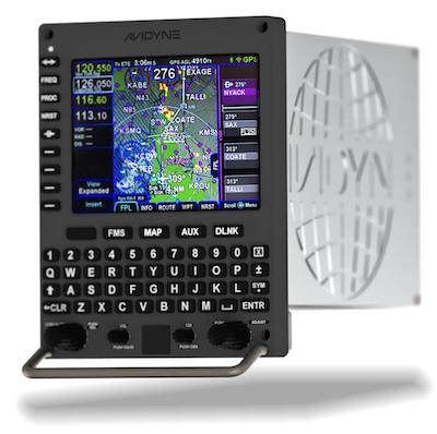
The Avidyne Atlas includes a Satellite-based Augmentation System (SBAS) GPS navigator with Required Navigation Performance (RNP) and Area Navigation (RNAV) capability, including Localizer Performance with Vertical Guidance (LPV), Lateral Navigation/ Vertical Navigation (LNAV/VNAV), LNAV-Only, and Approach Procedures with Vertical (APV) approach modes. The system also features a full QWERTY style keyboard, with Avidyne’s unique ‘Page & Tab’ and hybrid touch-screen user interface, allowing the pilot to get to any function in only one or two button pushes. The touch screen also provides full color Moving Map, plus geo-referenced Jeppesen Electronic Approach Charts and Airport Diagrams.
“We are really excited to announce the Avidyne Atlas multifunction flight management system for business aviation. Avidyne Atlas is a next-generation FMS replacement specifically targeted to provide console-equipped jet operators with a highly-capable navigation and flight management solution that pilots will find incredibly easy to use,” said Avidyne CEO Dan Schwinn. “We are already working closely with OEMs and also with several key MRO partners to identify launch platforms for the Avidyne ATLAS.”
“Based on proven Avidyne technology in use in thousands of units and with hundreds of thousands of flight hours, the all-in-one Avidyne Atlas really gives our Part 25 customers a powerful new option when upgrading their GPS navigation capabilities, especially in aircraft with older-generation EFIS displays where options have been limited,” said John Talmadge, Avidyne’s Director of Worldwide Sales. “Customers choosing the Avidyne Atlas will really appreciate its integrated design and lower installation costs, and more importantly they will see dramatic operational cost reduction, including big savings in recurring costs for updates of the FMS database and electronic approach plates, as well as extended warranty. This will be a great upgrade for operators that previously chose to do a compliance-only ADS-B Out upgrade, as Atlas will provide them with the full benefits that SBAS has to offer.”
(Source: Avidyne news release. Image provided)
More News
How To Get A Story On Aero-TV News/Feature Programming How do I submit a story idea or lead to Aero-TV? If you would like to submit a story idea or lead, please contact Jim Campbel>[...]
From 2011 (YouTube Edition): Aviation's Greatest Living Legend Talks About His Life In Aviation (Part 5, Final) ANN is pleased to offer you yet another snippet from the public conv>[...]
“All Air Traffic Controllers must get back to work, NOW!!! Anyone who doesn’t will be substantially ‘docked. For those Air Traffic Controllers who were GREAT PATR>[...]
Aero Linx: American Navion Society Welcome to the American Navion Society. Your society is here to support the Navion community. We are your source of technical and operating infor>[...]
Glideslope Intercept Altitude The published minimum altitude to intercept the glideslope in the intermediate segment of an instrument approach. Government charts use the lightning >[...]
 ANN FAQ: Contributing To Aero-TV

