Wed, Mar 04, 2015
Eight Major Metro Areas, Gulf Of Mexico Included In First Release
Garmin is rolling out a new version of Garmin Pilot for iOS, which adds a suite of features tailored to helicopter operators. These features incorporate helicopter route charts throughout eight U.S. metropolitan areas, including the Gulf of Mexico. Additionally, the latest version of Garmin Pilot allows pilots to easily identify and document the highest obstacle along their flight plan route, which fulfills Part 135 Helicopter Emergency Medical Service (HEMS) requirements set forth by the FAA.
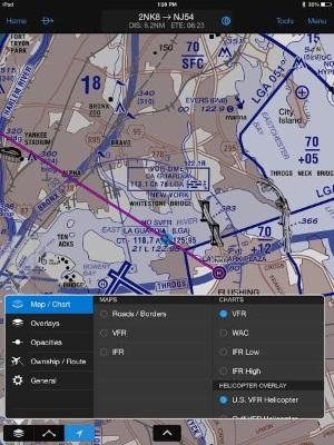
Helicopter Route Charts within Garmin Pilot provide detailed information applicable to the unique operations carried out by these operators. These three-color charts depict helicopter airways and routes, heliports with associated frequency and lighting capabilities, NAVAID information and obstructions. Additionally, pictorial symbols, roads and geographical features are notated on these charts for easier identification in urban areas with high concentrations of helicopter activity.
Garmin Pilot includes VFR and IFR Helicopter Route Charts for eight major metropolitan areas, including:
- Baltimore
- Boston
- Chicago
- Dallas-Ft.Worth
- Detroit
- Houston
- Los Angeles
- New York
Coverage for the Gulf of Mexico is also available, which includes offshore oil drilling platforms and more.
For helicopter air ambulance operators, rules recently established by the FAA requiring pilots to identify and document the highest obstacle along a planned route (§ 135.615), can now fulfill those requirements within Garmin Pilot. When entering a departure and destination airport pair, Garmin Pilot conveniently identifies the highest obstacle along the route of flight in mean sea level (MSL) and above ground level (AGL) within the Flight Plan page and notates the obstacle graphically on the moving map page.
The latest version of Garmin Pilot for iOS is available immediately as a free update, providing operators access to additional chart information tailored to helicopter operators and the opportunity to conveniently meet HEMS requirements.
(Images provided by Garmin)
FMI: www.garmin.com
More News
Convective SIGMET A weather advisory concerning convective weather significant to the safety of all aircraft. Convective SIGMETs are issued for tornadoes, lines of thunderstorms, e>[...]
Aero Linx: United Flying Octogenarians WELCOME to a most extraordinary group of aviators, the United Flying Octogenarians (UFO). Founded in 1982 with just a handful of pilots, we h>[...]
Pilot’s Decision To Attempt Takeoff With Frost Covering The Airplane’s Wings Analysis: The pilot of the light sport airplane was preparing to depart for a cross-country>[...]
“We’ve paid for the cable line’s repair for the customer and have apologized for the inconvenience this caused them...” Source: Some followup info from an A>[...]
Coupled Approach An instrument approach performed by the aircraft autopilot, and/or visually depicted on the flight director, which is receiving position information and/or steerin>[...]
 ANN's Daily Aero-Term (12.01.25): Convective SIGMET

