Wed, Mar 04, 2015
Eight Major Metro Areas, Gulf Of Mexico Included In First Release
Garmin is rolling out a new version of Garmin Pilot for iOS, which adds a suite of features tailored to helicopter operators. These features incorporate helicopter route charts throughout eight U.S. metropolitan areas, including the Gulf of Mexico. Additionally, the latest version of Garmin Pilot allows pilots to easily identify and document the highest obstacle along their flight plan route, which fulfills Part 135 Helicopter Emergency Medical Service (HEMS) requirements set forth by the FAA.
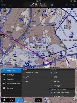
Helicopter Route Charts within Garmin Pilot provide detailed information applicable to the unique operations carried out by these operators. These three-color charts depict helicopter airways and routes, heliports with associated frequency and lighting capabilities, NAVAID information and obstructions. Additionally, pictorial symbols, roads and geographical features are notated on these charts for easier identification in urban areas with high concentrations of helicopter activity.
Garmin Pilot includes VFR and IFR Helicopter Route Charts for eight major metropolitan areas, including:
- Baltimore
- Boston
- Chicago
- Dallas-Ft.Worth
- Detroit
- Houston
- Los Angeles
- New York
Coverage for the Gulf of Mexico is also available, which includes offshore oil drilling platforms and more.

For helicopter air ambulance operators, rules recently established by the FAA requiring pilots to identify and document the highest obstacle along a planned route (§ 135.615), can now fulfill those requirements within Garmin Pilot. When entering a departure and destination airport pair, Garmin Pilot conveniently identifies the highest obstacle along the route of flight in mean sea level (MSL) and above ground level (AGL) within the Flight Plan page and notates the obstacle graphically on the moving map page.
The latest version of Garmin Pilot for iOS is available immediately as a free update, providing operators access to additional chart information tailored to helicopter operators and the opportunity to conveniently meet HEMS requirements.
(Images provided by Garmin)
FMI: www.garmin.com
More News
Ground Stop (GS) The GS is a process that requires aircraft that meet a specific criteria to remain on the ground. The criteria may be airport specific, airspace specific, or equip>[...]
Aero Linx: Australian Transport Safety Bureau (ATSB) The Australian Transport Safety Bureau (ATSB) improves safety and public confidence in aviation, marine and rail transport thro>[...]
“The Palo Alto stopover confirmed—yet again—that flight schools and aero-clubs are no longer just curious about electric training; they are ready to buy. In just >[...]
Pilot’s Failure To Maintain Clearance From The Water While Flying At A Low Altitude Analysis: The flight of two airplanes was in cruise flight on a north heading about 50 ft >[...]
Also: 48th Annual Air Race Classic, Hot Air Balloon Fire, FAA v Banning 100LL, Complete Remote Pilot The news Piper PA-18 Super Cub owners have been waiting for has finally arrived>[...]
 ANN's Daily Aero-Term (06.30.25): Ground Stop (GS)

