LMC To Develop Next-Gen Sensor Fusion Testbed | Aero-News Network
Aero-News Network
RSS icon RSS feed
podcast icon MP3 podcast
Subscribe Aero-News e-mail Newsletter Subscribe

Airborne Unlimited -- Most Recent Daily Episodes

Episode Date

Airborne-Monday

Airborne-Tuesday

Airborne-Wednesday Airborne-Thursday

Airborne-Friday

Airborne On YouTube

Airborne-Unlimited-11.17.25

AirborneNextGen-
11.11.25

Airborne-Unlimited-11.12.25

Airborne-FltTraining-11.13.25

AirborneUnlimited-11.14.25

LIVE MOSAIC Town Hall (Archived): www.airborne-live.net

Thu, Oct 19, 2017

LMC To Develop Next-Gen Sensor Fusion Testbed

Goal Is To Enhance Helicopter Survivability

The U.S. Army has awarded a $12 million contract to Lockheed Martin for the development of a Multi-Modal Sensor Fusion (MMSF) testbed for rotary-wing aircraft.

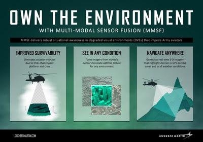
Under the service's Night Vision and Electronic Sensors Directorate (NVESD), the company is developing sensor fusion and integration technologies that enhance rotary-wing aircraft survivability and enable pilots to navigate safely in all environments, even when GPS is unavailable. The MMSF algorithms blend data from multiple sensor types to restore a pilot's situational awareness in degraded visual environments (DVEs).

"Current Lockheed Martin fire control systems enable pilots to own the night," said Paul Lemmo, vice president of Fire Control/SOF CLSS at Lockheed Martin Missiles and Fire Control. "Our next-generation MMSF technology will help them own the environment as well. Our work with NVESD and other DVE stakeholders will enable helicopter aircrews to operate more safely and effectively in even the most challenging visual environments."

During the 40-month effort, Lockheed Martin engineers will integrate government-furnished sensors in a reconfigurable, open-architecture testbed that supports the development of DVE systems for rotary-wing aircraft. Other activities include refining multi-modal fusion techniques and real-time 3-D mapping, and implementing symbols and cues for pilot sensor displays.

MMSF blends sensor data to generate real-time 3-D terrain maps of the area around the aircraft—maps that can identify and highlight obstacles to improve situational awareness for pilots, mission commanders and other platforms. Potential recipients of such capabilities include existing Army helicopters and Future Vertical Lift solutions.

(Infographic provided with Lockheed Martin news release)

FMI: www.lockheedmartin.com

Advertisement

More News

Aero-News: Quote of the Day (11.17.25)

“We achieved full mission success today, and I am so proud of the team. It turns out Never Tell Me The Odds had perfect odds—never before in history has a booster this >[...]

ANN's Daily Aero-Term (11.17.25): NonDirectional Beacon

NonDirectional Beacon An L/MF or UHF radio beacon transmitting nondirectional signals whereby the pilot of an aircraft equipped with direction finding equipment can determine his/h>[...]

NTSB Final Report: Fred L Wellman CH 750 Cruzer

About 5ft Above Ground Level, The Airplane Stalled, And The Left Wing Dropped Analysis: The pilot reported that this flight was conducted as part of phase 1 flight testing of the n>[...]

ANN's Daily Aero-Linx (11.17.25)

Aero Linx: Brodhead Pietenpol Association The Brodhead Pietenpol Association is a newly reorganized (in 2017) non-profit educational corporation that grew and developed from an ear>[...]

Airborne-NextGen 11.11.25: Archer Buys Hawthorne, Joby Conforms, Stranded Astros

Also: VerdeGo Contract, Medi-Carrier, Gambit 6 UCAV, Blade Urban Air Mobility Pilot Archer Aviation has inked a deal for control of Hawthorne Municipal Airport (HHR), also known as>[...]

blog comments powered by Disqus


Advertisement

Advertisement

Podcasts

Advertisement

© 2007 - 2025 Web Development & Design by Pauli Systems, LC