LMC To Develop Next-Gen Sensor Fusion Testbed | Aero-News Network
Aero-News Network
RSS icon RSS feed
podcast icon MP3 podcast
Subscribe Aero-News e-mail Newsletter Subscribe

Airborne Unlimited -- Most Recent Daily Episodes

Episode Date

Airborne-Monday

Airborne-Tuesday

Airborne-Wednesday Airborne-Thursday

Airborne-Friday

Airborne On YouTube

Airborne-Unlimited-06.23.25

Airborne-NextGen-06.24.25

AirborneUnlimited-06.25.25

Airborne-AffordableFlyers-06.26.25

AirborneUnlimited-06.27.25

Thu, Oct 19, 2017

LMC To Develop Next-Gen Sensor Fusion Testbed

Goal Is To Enhance Helicopter Survivability

The U.S. Army has awarded a $12 million contract to Lockheed Martin for the development of a Multi-Modal Sensor Fusion (MMSF) testbed for rotary-wing aircraft.

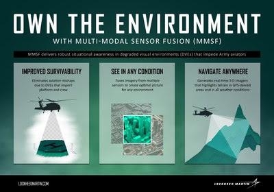
Under the service's Night Vision and Electronic Sensors Directorate (NVESD), the company is developing sensor fusion and integration technologies that enhance rotary-wing aircraft survivability and enable pilots to navigate safely in all environments, even when GPS is unavailable. The MMSF algorithms blend data from multiple sensor types to restore a pilot's situational awareness in degraded visual environments (DVEs).

"Current Lockheed Martin fire control systems enable pilots to own the night," said Paul Lemmo, vice president of Fire Control/SOF CLSS at Lockheed Martin Missiles and Fire Control. "Our next-generation MMSF technology will help them own the environment as well. Our work with NVESD and other DVE stakeholders will enable helicopter aircrews to operate more safely and effectively in even the most challenging visual environments."

During the 40-month effort, Lockheed Martin engineers will integrate government-furnished sensors in a reconfigurable, open-architecture testbed that supports the development of DVE systems for rotary-wing aircraft. Other activities include refining multi-modal fusion techniques and real-time 3-D mapping, and implementing symbols and cues for pilot sensor displays.

MMSF blends sensor data to generate real-time 3-D terrain maps of the area around the aircraft—maps that can identify and highlight obstacles to improve situational awareness for pilots, mission commanders and other platforms. Potential recipients of such capabilities include existing Army helicopters and Future Vertical Lift solutions.

(Infographic provided with Lockheed Martin news release)

FMI: www.lockheedmartin.com

Advertisement

More News

NTSB Prelim: Piper PA-23

Pilot Also Reported That Due To A Fuel Leak, The Auxiliary Fuel Tanks Were Not Used On June 4, 2025, at 13:41 eastern daylight time, a Piper PA-23, N2109P, was substantially damage>[...]

Classic Aero-TV: One Man’s Vietnam

From 2023 (YouTube Edition): Reflections on War’s Collective Lessons and Cyclical Nature The exigencies of war ought be colorblind. Inane social-constructs the likes of racis>[...]

NTSB Final Report: Capella Aircraft Corp FW1C50

Pilot Reported That He Was Unfamiliar With The Single Seat Amateur-Built Airplane And His Intent Was To Perform High-Speed Taxi Testing Analysis: The pilot reported that he was unf>[...]

Classic Aero-TV: Timber Tiger Touts Curtiss Jenny Replicas

From 2023 (YouTube Edition): First Kits to Ship October 2023 Having formerly resurrected the storied shape of the Ryan ST—in effigy, anyway—Montrose, Colorado-based Tim>[...]

ANN's Daily Aero-Term (07.04.25): Performance-Based Navigation (PBN) [ICAO]

Performance-Based Navigation (PBN) [ICAO] Area navigation based on performance requirements for aircraft operating along an ATS route, on an instrument approach procedure or in a d>[...]

blog comments powered by Disqus


Advertisement

Advertisement

Podcasts

Advertisement

© 2007 - 2025 Web Development & Design by Pauli Systems, LC