USGS To Conduct Aerial Fault Mapping In Oklahoma | Aero-News Network
Aero-News Network
RSS icon RSS feed
podcast icon MP3 podcast
Subscribe Aero-News e-mail Newsletter Subscribe

Airborne Unlimited -- Most Recent Daily Episodes

Episode Date

Airborne-Monday

Airborne-Tuesday

Airborne-Wednesday Airborne-Thursday

Airborne-Friday

Airborne On YouTube

Airborne-Unlimited-09.15.25

AirborneNextGen-
09.09.25

Airborne-Unlimited-09.10.25

Airborne-AffordableFlyers-09.11.25

AirborneUnlimited-09.12.25

Fri, Aug 18, 2017

USGS To Conduct Aerial Fault Mapping In Oklahoma

Surveys Will Take Six To 10 Weeks To Complete

Scientists with the U.S. Geological Survey and Oklahoma Geological Survey are teaming up to better understand the location of deep faults and subsurface geology via airborne technology.

USGS and OGS are contracting Goldak Airborne Surveys to conduct surveys that will fly over 18 counties in the southwestern and north-central part of the state. The goal is to capture 3-D images of geology beneath the Earth’s surface for earthquake hazard and mineral resources.

Weather permitting, the surveys will take approximately 6-10 weeks to complete. Operations will be based out of Altus, Oklahoma.

“Oklahoma has been experiencing increased seismicity since about 2009. Many of these earthquakes occur on faults that haven’t been mapped,” said USGS scientist and project lead Dr. Anji Shah. “In order to better understand local seismic hazards, the USGS and OGS will use the new data to work towards improved fault maps.”

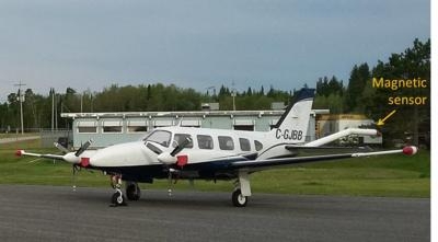
Instruments on the airplane will measure variations in the Earth’s magnetic field created by different rock types up to several miles beneath the surface. The magnetic field maps will help with imaging faults as well as intrusions, which are rocks formed by ancient volcanic eruptions that never reached the surface. The scientific instruments on the airplane are completely passive, with no emissions that pose a risk to humans, animals, or plant life.

Survey areas will include parts of Alfalfa, Beckham, Comanche, Greer, Harmon, Kiowa, Jackson, Lincoln, Logan, Major, Noble, Pawnee, Payne, Pottawatomie, Stephens, Tillman, Woods and Woodward counties.

(Image provided with USGS news release)

FMI: www.usgs.gov

Advertisement

More News

NTSB Final Report: Evektor-Aerotechnik A S Harmony LSA

Improper Installation Of The Fuel Line That Connected The Fuel Pump To The Four-Way Distributor Analysis: The airplane was on the final leg of a flight to reposition it to its home>[...]

ANN's Daily Aero-Term (09.15.25): Decision Altitude (DA)

Decision Altitude (DA) A specified altitude (mean sea level (MSL)) on an instrument approach procedure (ILS, GLS, vertically guided RNAV) at which the pilot must decide whether to >[...]

Aero-News: Quote of the Day (09.15.25)

“With the arrival of the second B-21 Raider, our flight test campaign gains substantial momentum. We can now expedite critical evaluations of mission systems and weapons capa>[...]

Airborne 09.12.25: Bristell Cert, Jetson ONE Delivery, GAMA Sales Report

Also: Potential Mars Biosignature, Boeing August Deliveries, JetBlue Retires Final E190, Av Safety Awareness Czech plane maker Bristell was awarded its first FAA Type Certification>[...]

Airborne 09.10.25: 1000 Hr B29 Pilot, Airplane Pile-Up, Haitian Restrictions

Also: Commercial A/C Certification, GMR Adds More Bell 429s, Helo Denial, John “Lucky” Luckadoo Flies West CAF’s Col. Mark Novak has accumulated more than 1,000 f>[...]

blog comments powered by Disqus


Advertisement

Advertisement

Podcasts

Advertisement

© 2007 - 2025 Web Development & Design by Pauli Systems, LC