The NEXT Big Storm? Hanna Now Looks Like Another Gulf of Mexico
Storm Due to a Developing High
 NASA tells ANN that
over the last couple of days, the forecast track of Tropical Storm
Hanna has changed. Several days ago, the forecast models were
taking her on a possible track toward Florida, now, forecast models
agree that she'll be taking a southeast track toward Cuba.
NASA tells ANN that
over the last couple of days, the forecast track of Tropical Storm
Hanna has changed. Several days ago, the forecast models were
taking her on a possible track toward Florida, now, forecast models
agree that she'll be taking a southeast track toward Cuba.
An intensifying subtropical high pressure system is the reason
for Hanna's change in track. It's located to the north-northwest of
Hanna, and because High pressure systems have a clockwise wind
flow, it will steer Hanna downward on a west-southwest track from
heading to an almost a 3 o'clock position (due west of where it is
now) to a 6 o'clock position (southward).
Hanna's Potential Effect
In the short term, The Bahamas, Turks and Caicos are under the
gun for Tropical Storm conditions, but the southeastern U.S. coast
is going to deal with dangerous rip currents over the next couple
of days. Beachgoers in all of these areas should take serious
precautions.
CloudSat Looks at Hanna Sliced in Half
NASA's CloudSat satellite's Cloud Profiling Radar captured a
sideways look across Hanna on Aug. 29 at 6:15 UTC (2:15 a.m. EDT).
For comparison, the top image is from the National Oceanic and
Atmospheric Administration's Geostationary Operational
Environmental Satellite (GOES-12) around the same time.
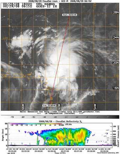
The red line through the GOES satellite image shows the vertical
cross section of radar, basically what Fay's clouds looked like
sideways. The colors indicate the intensity of the reflected radar
energy. The top of Fay's clouds are over 14 kilometers (8.5 miles)
high.
The blue areas along the top of the clouds indicate cloud ice,
while the wavy blue lines on the bottom center of the image
indicate intense rainfall. Notice that the solid line along the
bottom of the panel, which is the ground, disappears in this area
of intense precipitation. It is likely that in the area the
precipitation rate exceeds 30mm/hr (1.18 inches/hour) based on
previous studies.
Hanna's Position as of Saturday, August 30, 2008
Tropical storm watches have been issued for portions of the
Bahamas and the Turks and Caicos Islands. At 11 a.m. EDT, the
government of the Bahamas has issued a tropical storm watch for the
southeastern Bahamas.
At 11:00 a.m. EDT Hanna's center was near latitude 21.9 north
and longitude 66.4 west or about 240 miles north of San Juan,
Puerto Rico and about 305 miles east of Grand Turk Island. Hanna
has slowed from 12 to 8 mph westward and will gradually turn
west-northwest before heading back in a westerly direction on Aug.
31.
Hanna's maximum sustained winds remain near 50 mph with higher
gusts. Little change in strength is forecast today but Hanna could
be near hurricane strength on Sunday. Estimated minimum central
pressure has dropped from1001 to 1000 millibars, which is a slight
indication of strengthening. The Leeward Islands could receive
between 1 and 2 inches of rainfall as Hanna passes by.
 NTSB Final Report: Rutan Long-EZ