GOES-17 Mishap Investigation Board Study Completed | Aero-News Network
Aero-News Network
RSS icon RSS feed
podcast icon MP3 podcast
Subscribe Aero-News e-mail Newsletter Subscribe

Airborne Unlimited -- Most Recent Daily Episodes

Episode Date

Airborne-Monday

Airborne-Tuesday

Airborne-Wednesday Airborne-Thursday

Airborne-Friday

Airborne On YouTube

Airborne-Unlimited-07.07.25

Airborne-NextGen-07.08.25

AirborneUnlimited-07.09.25

Airborne-FlightTraining-07.10.25

AirborneUnlimited-07.11.25

Wed, Aug 07, 2019

GOES-17 Mishap Investigation Board Study Completed

Most Likely Cause Of The ABI Cooling Issue Is A Blockage In The Instrument’s Loop Heat Pipes

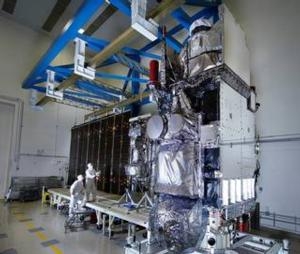
A Mishap Investigation Board appointed by NASA and the National Oceanic and Atmospheric Administration (NOAA) has identified the most likely cause for an instrument issue aboard NOAA’s Geostationary Operational Environmental Satellite (GOES)-17 satellite that launched March 1, 2018 from Cape Canaveral Air Force Station in Florida.

During postlaunch testing of the satellite’s Advanced Baseline Imager (ABI), teams discovered the instrument’s infrared detectors could not be maintained at the required temperatures during some orbital conditions, which resulted in a partial loss of three of the instruments 16 bands during certain times of the year.

The ABI is GOES-17’s primary instrument for imaging Earth’s weather, oceans, and environment. It views the Earth with 16 spectral bands including two visible, four near-infrared, and 10 infrared channels.

The mishap board was tasked with gathering and analyzing information, and identifying the proximate causes, root causes, and contributing factors related to the ABI performance issues. It concluded the most likely cause of the ABI cooling issue is a blockage in the instrument’s loop heat pipes, which transfer heat from the ABI electronics to its radiator. The blockage restricted the flow of coolant in the loop heat pipes, causing the ABI to overheat and reducing the sensitivity of infrared sensors.

NOAA and NASA have adjusted the instrument operations, and are working to improve the quality of the data in order to reduce the impact of the cooling issue.

GOES-17, in the GOES-West position, is helping forecasters track weather from torrential rain events to wildfires and other environmental hazards throughout the U.S. western region, including California, Alaska and Hawaii. Also, GOES-17 is monitoring typhoons in the eastern Pacific Ocean, including Hawaii.

(Image provided with NASA news release)

FMI: www.nasa.gov/reports

Advertisement

More News

Classic Aero-TV: Up Close And Personal - The Aeroshell Aerobatic Team at Oshkosh

From 2014 (YouTube Version): One Of The Airshow World's Pre-Eminent Formation Teams Chats About The State Of The Industry At EAA AirVenture 2014, ANN News Editor Tom Patton gets th>[...]

ANN's Daily Aero-Term (07.13.25): Tactical Air Navigation (TACAN)

Tactical Air Navigation (TACAN) An ultra-high frequency electronic rho-theta air navigation aid which provides suitably equipped aircraft a continuous indication of bearing and dis>[...]

ANN's Daily Aero-Linx (07.13.25)

Aero Linx: Doobert Hi, we're Chris & Rachael Roy, founders and owners of Doobert. Chris is a technology guy in his “day” job and used his experience to create Doobe>[...]

NTSB Prelim: Pitts S2

The Airplane Was Spinning In A Nose-Down Attitude Before It Impacted Terrain On June 20, 2025, at 0900 eastern daylight time, a Pitts Aerobatics S-2B, N79AV, was destroyed when it >[...]

Airborne 07.09.25: B-17 Sentimental Journey, Airport Scandal, NORAD Intercepts

Also: United Elite Sues, Newark ATC Transitions, Discovery Moves?, Textron @ KOSH The Commemorative Air Force Airbase Arizona is taking its “Flying Legends of Victory Tour&rd>[...]

blog comments powered by Disqus


Advertisement

Advertisement

Podcasts

Advertisement

© 2007 - 2025 Web Development & Design by Pauli Systems, LC