Mon, May 15, 2017
New Version Compatible With Multiple ADS-B Devices
iFlightPlanner for iPad v3.0 has been released by the company. The app for iPad now offers compatibility with ADS-B devices from 7 different manufacturers – Dual, Levil, Sagetech, SkyRadar, Stratux, L-3, and NavWorx.
“We were the first to bring wireless sync technology to the EFB market when we first introduced iFlightPlanner for iPad,” said Andy Matthews, iFlightPlanner’s Director of Business Development. “This new version of the app gives pilots the tools they need to make their flight planning process safer and much more efficient than with any other product. It eliminates the need to use one resource to plan a flight and copy-paste a route into another to fly it. iFlightPlanner.com and iFlightPlanner for iPad do it all for pilots, seamlessly.”
Other highlights include:
- Ability to select your default app startup view (Home, Airports, Flights, or Map)
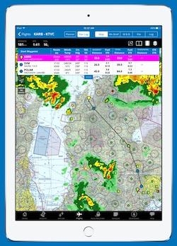
- Reorganized planning and mapping interface for enhanced pre-flight and in cockpit usability
- Expanded weight & balance functionality to include %MAC calculations for turbine aircraft
- One-touch transfer of flight plans to Jeppesen FliteDeck apps
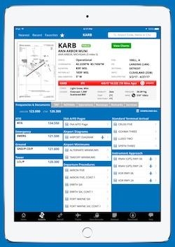
- Current crosswind component for all runways in Airport/Facility Directory
- New Attitude/Heading Indicator with data from AHRS compatible devices
- Added logbook fields for personalized data tracking
- X-Plane 9 integration (in addition to existing X-Plane 10 integration)
This new version further distinguishes iFlightPlanner as the leader in cloud-based flight planning, making it the only EFB with comprehensive 2-way sync of pilot information, aircraft profiles, routes, weather briefs, weight & balance calculations, flight plan filing status, and digital flight track and logbook data between your iPad and the web.
Pilots are encouraged to take advantage of the 30-day FREE trial to iFlightPlanner Premium Plus, iFlightPlanner’s top-level membership. After the trial, pilots may elect to continue with an iFlightPlanner Free, iFlightPlanner Premium, or iFlightPlanner Premium Plus membership. All memberships include comprehensive web-based flight planning, while premium members have access to enhanced features both online and in the app. For iFlightPlanner Free members, iFlightPlanner for iPad will provide view-only access to the flights planned on their website.
(Images provided with iFlightPlanner media release)
More News
Outboard Section Of The Right Wing And The Right Flap Separated In Flight And The Airplane Impacted A Farm Field Analysis: The pilot was approaching his destination airport under i>[...]
Final Approach Fix The fix from which the final approach (IFR) to an airport is executed and which identifies the beginning of the final approach segment. It is designated on Gover>[...]
"Our choice of when to respond, how to respond and on which targets to respond is a consideration that we make every time... Netanyahu also noted that anyone attacking Israel &ldqu>[...]
Estimated (EST) When used in NOTAMs “EST” is a contraction that is used by the issuing authority only when the condition is expected to return to service prior to the e>[...]
Aero Linx: Coalition of Airline Pilots Associations (CAPA) The Coalition of Airline Pilots Associations (CAPA) is the world’s largest pilot trade association representing ove>[...]
 NTSB Final Report: Cessna 177B

