Tue, Dec 01, 2015
Jacksonville University In NE Florida Hopes To Study Oyster Reefs In The St. Johns River
Students at Jacksonville University in northeast Florida have turned to the crowdfunding site experiment.com to obtain funding for a project that would use UAVs to study oyster reefs in the St. Johns River.
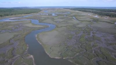
Students within the Jacksonville University School of Aviation are working collaboratively with the Marine Science Research Institute and the Department of Geography and the Environment to use unmanned aircraft systems to create orthomosaic maps and 3D models of the oyster reefs in the Northern Jacksonville area. The students will begin mapping in January 2016. The maps and findings will be presented to the backers of this project as well as our partners for further analysis.
According to the crowdfunding page, the oyster harvest in the St. Johns River was stopped over 15 years ago when monitoring stations used to determine the health of the oyster beds were shut down. Now, there is an increasing interest in reopening those oyster beds to commercial fishing.
The use of Unmanned Aircraft Systems (UAS) for monitoring the health of oyster beds in Duval County is a sustainable, cost effective solution. This allows database information to be collected in an efficient and environmentally friendly manner. UAS represent a low carbon footprint solution as compared to manned aircraft; the risk of hazardous waste spill from UAS is low; and the time and resources required to collect the data are significantly reduced. Information gathered through this research will be used to assess changes to the reefs over time and make recommendations to governmental entities about reopening the oyster beds for harvesting.
The School of Aviation's immediate goal is to engage students operational capabilities utilizing drones to create orthomosaic maps and 3D models with our DJI Inspire 1 drones. Once trained on the mapping and modeling software, the students will begin to map the natural resource area of operation and present findings and reef measurements to our collaborative partners for further analysis. Students will use UAS 3D modeling techniques, which will allow precise measurements to be made of the oyster reefs without creating unwanted damage to the ecosystem. Measurement will be provided to our collaborative partners to assess the rate of growth of the reefs. Students will share their research with our donors periodically and will provide a summary of findings upon project completion.
The project has a fundraising goal of $4,300 ... but as of Monday had only had $30 pledged with 18 days remaining.
(Image from Jacksonville University YouTube video)
More News
“While legendary World War II aircraft such as the Corsair and P-51 Mustang still were widely flown at the start of the Korean War in 1950, a new age of jets rapidly came to >[...]
Decision Altitude (DA) A specified altitude (mean sea level (MSL)) on an instrument approach procedure (ILS, GLS, vertically guided RNAV) at which the pilot must decide whether to >[...]
Aero Linx: National Aviation Safety Foundation (NASF) The National Aviation Safety Foundation is a support group whose objective is to enhance aviation safety through educational p>[...]
Also: Cal Poly Aviation Club, $$un Country, Arkansas Aviation Academy, Teamsters Local 2118 In response to two recent general aviation accidents that made national headlines, more >[...]
“The FAA is tasked with ensuring our skies are safe, and they do a great job at it, but there is something about the system that is holding up the medical process. Obviously,>[...]
 Aero-News: Quote of the Day (04.28.25)