Arcturus UAV And Urban Robotics Fly 3-D Imager | Aero-News Network
Aero-News Network
RSS icon RSS feed
podcast icon MP3 podcast
Subscribe Aero-News e-mail Newsletter Subscribe

Airborne Unlimited -- Most Recent Daily Episodes

Episode Date

Airborne-Monday

Airborne-Tuesday

Airborne-Wednesday Airborne-Thursday

Airborne-Friday

Airborne On YouTube

Airborne-Unlimited-04.14.25

Airborne-NextGen-04.15.25

AirborneUnlimited-04.16.25

Airborne-AffordableFliers-04.17.25

SunnFun-DayFour-04.03.25

Tue, Jan 28, 2014

Arcturus UAV And Urban Robotics Fly 3-D Imager

Device Can Create 3-D Images In Near-Real Time, Maker Says

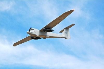
A sensor system designed to create 3-D reconstructions in near-real time and output high-resolution digital elevation models, LIDAR-like datasets, and wide area maps has been flown on an Arcturus UAV T-20 Tier II unmanned aerial vehicle. The system, called GeoDragon, is enclosed in a wing-mounted pod and is capable of high resolution 2-D and 3-D image capture.

Urban Robotics in Portland, OR, which designed the sensor, says among its "unique aspects" are low weight (equating to longer endurance and loiter time,) small operational footprint on the ground (1 or 2 full size pick-up trucks,) a quick mount/dismount pod, quiet operation (the T-20 utilizes a modified 4-stroke engine,) and the ability to fly simultaneously with other payloads on the T-20, such as EO/IR.

GeoDragon imagery is post-processed using automated 3-D algorithms to rapidly generate large mapping and modeling datasets. Urban Robotics develops software and hardware solutions for 3-D ISR, remote sensing and geospatial applications, including collection, post-processing, and data management. 

The aircraft was built by Arcturus UAV in Rohnert Park, CA. Urban Robotics says the GeoDragon adds significant 3-D imaging and mapping capabilities to the T-20 UAV. The system is scheduled to be released in mid-2014.

(Image provided by Arcturus)

FMI: www.arcturus-uav.com

Advertisement

More News

Aero-News: Quote of the Day (04.21.25)

"That, to me, is the real exciting part that you know that this airplane somehow had a history with a family or a person. That's kind of the cool stuff... If you find the right swi>[...]

ANN's Daily Aero-Term (04.21.25): Terminal Radar Service Area

Terminal Radar Service Area Airspace surrounding designated airports wherein ATC provides radar vectoring, sequencing, and separation on a full-time basis for all IFR and participa>[...]

ANN's Daily Aero-Linx (04.21.25)

Aero Linx: The People's Mosquito Ltd The De Havilland DH.98 Mosquito enjoys legendary status. This exemplar of British aeronautical design genius is moulded around its graceful lin>[...]

Airborne-NextGen 04.22.25: NYC eVTOL Network, ForgeStar-1, Drone Safety Day

Also: CiES Documents, Hypersonic Tech, SKYTRAC Health Monitoring, Skyryse Archer Aviation announced a blueprint for an eVTOL network in New York City that would connect travelers b>[...]

Aero-News: Quote of the Day (04.22.25)

“At Electra, we are on a mission to deliver a new era of aviation, a leap forward in advanced air mobility that is both transformational and practical. The EL9 Ultra Short op>[...]

blog comments powered by Disqus


Advertisement

Advertisement

Podcasts

Advertisement

© 2007 - 2025 Web Development & Design by Pauli Systems, LC