Arcturus UAV And Urban Robotics Fly 3-D Imager | Aero-News Network
Aero-News Network
RSS icon RSS feed
podcast icon MP3 podcast
Subscribe Aero-News e-mail Newsletter Subscribe

Airborne Unlimited -- Most Recent Daily Episodes

Episode Date

Airborne-Monday

Airborne-Tuesday

Airborne-Wednesday Airborne-Thursday

Airborne-Friday

Airborne On YouTube

Airborne-Unlimited-05.05.25

Airborne-NextGen-05.06.25

AirborneUnlimited-05.07.25

Airborne-Unlimited-05.01.25

AirborneUnlimited-05.02.25

Tue, Jan 28, 2014

Arcturus UAV And Urban Robotics Fly 3-D Imager

Device Can Create 3-D Images In Near-Real Time, Maker Says

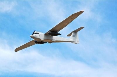
A sensor system designed to create 3-D reconstructions in near-real time and output high-resolution digital elevation models, LIDAR-like datasets, and wide area maps has been flown on an Arcturus UAV T-20 Tier II unmanned aerial vehicle. The system, called GeoDragon, is enclosed in a wing-mounted pod and is capable of high resolution 2-D and 3-D image capture.

Urban Robotics in Portland, OR, which designed the sensor, says among its "unique aspects" are low weight (equating to longer endurance and loiter time,) small operational footprint on the ground (1 or 2 full size pick-up trucks,) a quick mount/dismount pod, quiet operation (the T-20 utilizes a modified 4-stroke engine,) and the ability to fly simultaneously with other payloads on the T-20, such as EO/IR.

GeoDragon imagery is post-processed using automated 3-D algorithms to rapidly generate large mapping and modeling datasets. Urban Robotics develops software and hardware solutions for 3-D ISR, remote sensing and geospatial applications, including collection, post-processing, and data management. 

The aircraft was built by Arcturus UAV in Rohnert Park, CA. Urban Robotics says the GeoDragon adds significant 3-D imaging and mapping capabilities to the T-20 UAV. The system is scheduled to be released in mid-2014.

(Image provided by Arcturus)

FMI: www.arcturus-uav.com

Advertisement

More News

ANN's Daily Aero-Term (05.05.25): Circle To Runway (Runway Number)

Circle To Runway (Runway Number) Used by ATC to inform the pilot that he/she must circle to land because the runway in use is other than the runway aligned with the instrument appr>[...]

ANN's Daily Aero-Linx (05.05.25)

Aero Linx: National Aviation Safety Foundation (NASF) The National Aviation Safety Foundation is a support group whose objective is to enhance aviation safety through educational p>[...]

NTSB Prelim: De Havilland DHC-1

At Altitude Of About 250-300 Ft Agl, The Airplane Experienced A Total Loss Of Engine Power On November 6, 2024, at 1600 central standard time, a De Havilland DHC-1, N420TD, was inv>[...]

Classic Aero-TV: The Boeing Dreamliner -- Historic First Flight Coverage

From 2009 (YouTube Edition): Three Hour Flight Was 'Flawless' -- At Least, Until Mother Nature Intervened For anyone who loves the aviation business, this was a VERY good day. Afte>[...]

Airborne-NextGen 05.06.25: AF Uncrewed Fighters, Drones v Planes, Joby Crew Test

Also: AMA Names Tyler Dobbs, More Falcon 9 Ops, Firefly Launch Unsuccessful, Autonomous F-16s The Air Force has begun ground testing a future uncrewed jet design in a milestone tow>[...]

blog comments powered by Disqus


Advertisement

Advertisement

Podcasts

Advertisement

© 2007 - 2025 Web Development & Design by Pauli Systems, LC