Satellite-Connected Puma UAS Inspects Virginia Power Lines | Aero-News Network
Aero-News Network
RSS icon RSS feed
podcast icon MP3 podcast
Subscribe Aero-News e-mail Newsletter Subscribe

Airborne Unlimited -- Most Recent Daily Episodes

Episode Date

Airborne-Monday

Airborne-Tuesday

Airborne-Wednesday Airborne-Thursday

Airborne-Friday

Airborne On YouTube

Airborne-Unlimited-06.23.25

Airborne-NextGen-06.24.25

AirborneUnlimited-06.25.25

Airborne-AffordableFlyers-06.26.25

AirborneUnlimited-06.27.25

Thu, Apr 20, 2017

Satellite-Connected Puma UAS Inspects Virginia Power Lines

Demonstrates BVLOS Operations For Industrial Uses

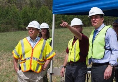
A team from AeroVironment, Dominion Virginia Power, the Mid-Atlantic Aviation Partnership and communications company Ligado Networks conducted two days of demonstrations of beyond-line-of-sight powerline inspections using a satellite network, wrapping up with a public demonstration that included a visit by Virginia Sen. Mark Warner on Wednesday, April 12. 

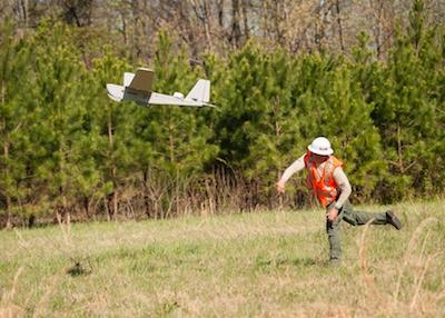
The demonstration, conducted in Virginia’s rural Buckingham County, used an AeroVironment Puma connected to Ligado’s SkyTerra 1 satellite system. The Puma flew over the lines — and then out of sight — before returning to land in a field next to the lines. 

“I’ve seen demonstrations dozens of times,” Warner said. “In the last couple of years I’ve seen this evolution. And kind of the holy grail has always been beyond line of sight, and I saw my first beyond line of sight today.” 

Warner briefly took control of the system, saying later that it took him, “an old guy,” only 30 seconds to figure it out with some coaching. 

“You get anybody that’s a Millennial, they’ll pick it up immediately,” he said. 

The team actually tested three network configurations, according to Ligado Chief Technology Officer Tamara Casey. One was a souped-up Wi-Fi signal, which they pushed out to 10 kilometers. The second was a 5 mhz licensed spectrum, which Ligado already uses, and which was able to extend to 14 miles. 

The third was the satellite connection, based on the SkyTerra 1, which uses a 22-meter reflector-based antenna, the largest in service on a commercial satellite. 

Casey said Ligado foresees a combination of networks for commercial UAS use, including satellite communication for command and control, and terrestrial networks for more data-heavy data needs. Basically, the satellite could fly the aircraft and more common ground stations could handle the payloads. 

Dominion Virginia Power already uses drones to inspect its powerlines, as an augmentation to manned helicopter inspections. Steve Eisenrauch, who manages transmission, forestry and line services for the utility, says contractor Hazon Solutions, based in Virginia Beach, handles the drone inspections. 

Eisenrauch says the main benefit from using small UAS is the ability to get multiple angles of view of the lines, something that’s hard to do with manned helicopters. They aren’t saving money or time as of yet, but that’s partly due to the requirement to keep them in sight at all times. 

“That’s where beyond line of sight is going to be so important,” he said. 

Warner, for his part, said he is enthusiastic about the technology. Like many observers who see a Puma land for the first time, he was surprised that it’s intended to break apart on landing to dissipate its energy. 

“I think unmanned, whether it’s aerial, maritime or land-based, has the potential to be the same thing that the wireless revolution brought about, maybe more extensive,” Warner said, noting that Virginia has an unmanned systems commission to push forward on developing that technology in the state. 

He also urged California-based AeroVironment to relocate its UAS production from “a very high expense state to a pro-business state like Virginia.” 

(Images provided with Mid Atlantic Aviation Partnership news release)

FMI: www.maap.ictas.vt.edu

Advertisement

More News

ANN's Daily Aero-Linx (06.29.25)

Aero Linx: Transport Canada We are a federal institution, leading the Transport Canada portfolio and working with our partners. Transport Canada is responsible for transportation p>[...]

ANN's Daily Aero-Term (06.29.25): Gross Navigation Error (GNE)

Gross Navigation Error (GNE) A lateral deviation from a cleared track, normally in excess of 25 Nautical Miles (NM). More stringent standards (for example, 10NM in some parts of th>[...]

Classic Aero-TV: Anticipating Futurespace - Blue Origin Visits Airventure 2017

From AirVenture 2017 (YouTube Edition): Flight-Proven Booster On Display At AirVenture… EAA AirVenture Oshkosh is known primarily as a celebration of experimental and amateu>[...]

NTSB Final Report: Cirrus SR22

Aircraft Parachute System (CAPS) Was Deployed About 293 Ft Above Ground Level, Which Was Too Low To Allow For Full Deployment Of The Parachute System Analysis: The day before the a>[...]

Airborne Affordable Flyers 06.26.25: PA18 Upgrades, ‘Delta Force’, Rhinebeck

Also: 48th Annual Air Race Classic, Hot Air Balloon Fire, FAA v Banning 100LL, Complete Remote Pilot The news Piper PA-18 Super Cub owners have been waiting for has finally arrived>[...]

blog comments powered by Disqus


Advertisement

Advertisement

Podcasts

Advertisement

© 2007 - 2025 Web Development & Design by Pauli Systems, LC